
Longwood Gardens near Kennett Square in Chester County is located on the drainage divide between Brandywine Creek to the east and Red Clay Creek to the west. A former east-to-west oriented water flow channel crosses the present-day Brandywine Creek-Red Clay Creek divide on the Longwood Gardens grounds on the north side of the main conservatory building. Evidence in the Longwood Gardens region suggests this former water flow channel was one of several diverging and converging flood flow channels moving water to the south oriented East Branch Red Clay Creek valley prior to headward erosion of the south-southeast oriented Brandywine Creek valley. Headward erosion of the deeper Brandywine Creek valley (and a southeast oriented Pocopson Creek valley segment) beheaded the west and southwest oriented flood flow channels and caused flood flow on the east and northeast ends of the beheaded flood flow channels to reverse flow direction and to create what are today east-northeast and northeast oriented streams flowing as barbed tributaries to Brandywine Creek.

Figure 1: Regional map showing the Longwood Gardens location at location 1 on the drainage divide between south-southeast oriented Brandywine Creek (in northwest corner of map) and south oriented East Branch Red Clay Creek (near southwest corner of map). See text for additional discussion. United States Geological Survey map digitally presented using National Geographic TOPO software.
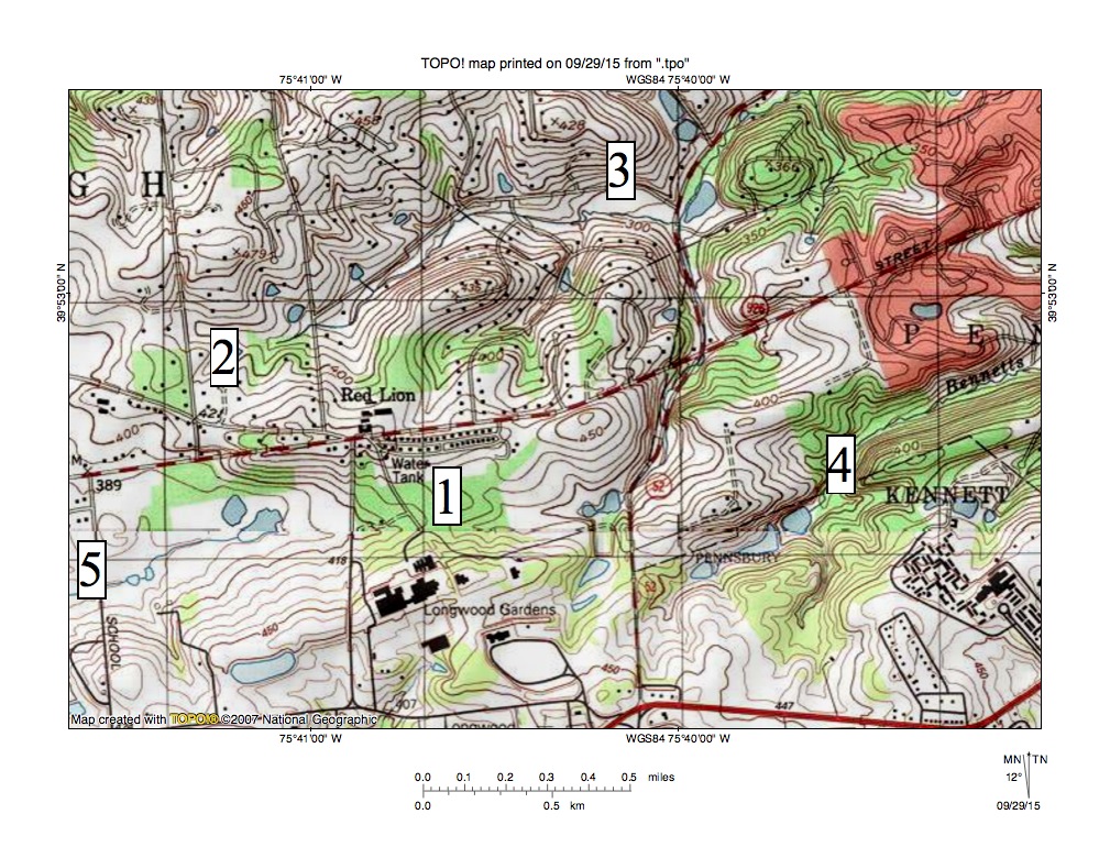
Figure 2: Enlargement of the figure 1 region immediately surrounding Longwood Gardens. United States Geological Survey map digitally presented using National Geographic TOPO software.
Figure 1 provides a regional map of the Longwood Gardens area and figure 2 provides an enlargement of the Longwood Gardens area from the figure 1 map. Location 1 is the former east-to-west oriented water flow channel on the Longwood Gardens grounds. Brandywine Creek can be seen flowing in a south-southeast direction across the northeast corner of figure 1 and the East Branch Red Clay Creek flows in a south direction near the southwest corner of figure 1. Just east of location 1 is a north-northeast oriented stream that flows to northeast and southeast oriented Pocopson Creek, which then joins Brandywine Creek. Location 4 identifies east-northeast oriented Bennetts Run, which flows to Brandywine Creek as a barbed tributary. Note how the north-northeast oriented stream and Bennetts Run both originate in the same area near the east end of the Longwood Gardens property and then diverge to flow in different directions only to end up near each other again in the Brandywine Creek valley. Location 5 identifies a west-southwest tributary to the south oriented East Branch Red Clay Creek. Locations 2 and 3 identify the ends of another former water flow channel located north of Red Lion.
The former water flow channels seen at and near the Longwood Gardens can best be explained in the context of diverging and converging flood flow channels typical of those found in flood formed anastomosing channel complexes. Evidence seen in figures 1 and 2 suggests the floodwaters were flowing in a southwest or west-southwest direction and had been captured by headward erosion of the south oriented East Branch Red Clay Creek valley. Headward erosion of the deep south-southeast oriented Brandywine Creek valley (and the southeast oriented Pocopson Creek valley segment) next beheaded the flood flow channels in sequence from south to north and in the process reversed flow on the northeast and east-northeast ends of the beheaded flood flow channels. Because the flood flow channels were beheaded in sequence from south to north reversed flood flow in a newly beheaded flood flow could capture floodwaters from flood flow channels further to the north. Such captures enabled the reversed flood flow channels to erode significant northeast and east-northeast oriented valleys. The source of the floodwaters cannot be determined from southeast Pennsylvania evidence although melt water from a large continental ice sheet would be a logical floodwater source

Leave a comment