
Two completely different Valley Creeks originate almost adjacent to each other in the South Valley Hills near Glenloch (between Malvern and Exton) and then flow parallel to each other in a north direction in deep narrow valleys down a steep slope onto the west-southwest to east-northeast oriented Chester Valley floor where the eastern Valley Creek (Valley Creek East) turns to flow in an east-northeast direction while the western Valley Creek (Valley Creek West) turns in a west-southwest direction. The divide between the two Valley Creeks where they turn to flow in opposite directions is approximately 200 feet lower in elevation than the elevation where the two streams originate.

Figure 1: Valley Creek East is identified with the number 1 and originates in the South Valley Hills and flows onto the Chester Valley floor and then in an east-northeast direction along the Chester Valley floor. Valley Creek West is identified with the number 2 and also originates in the South Valley Hills and flows adjacent to and parallel to Valley Creek East onto the Chester Valley floor where it turns in a west-southwest direction. Streams identified by the number 3 are headwaters of Chester Creek. United States Geological Survey map digitally presented using National Geographic TOPO software.
Figure 1 illustrates Valley Creek East and Valley Creek West originating almost next to each other in South Valley Hills (south of the west-southwest to east-northeast trending Chester Valley) and then flowing parallel to each in north directions onto the Chester Valley floor before diverging to flow in two opposing directions. Valley Creek East is labeled with the number 1 while Valley Creek West is labeled with the number 2. Note how once on the Chester Valley floor Valley Creek East turns to flow in an east-northeast direction along the Chester Valley floor while Valley Creek West makes a more abrupt turn to flow in a west-southwest direction along the Chester Valley floor. Valley Creek East flows to Schuylkill River and Valley Creek West flows to the East Branch Brandywine Creek with Brandywine Creek flowing to the Delaware River. The drainage divide between the two Valley Creeks is also the Delaware River-Schuylkill River drainage divide. The number 3 marks the heads of south oriented streams that converge to create south and south-southeast oriented Chester Creek, which flows to the southwest oriented Delaware River.
Note how the divide on the Chester Valley floor between the two opposing Valley Creeks is marked by only three 10-foot contour lines while the north and south Chester Valley walls rise approximately 200 feet high above the Chester Valley floor. Limestone and other carbonate bedrock are found on the Chester Valley floor and more resistant schist, gneiss, quartzite and other metamorphic rocks make up the hills on either side of the Chester Valley, yet the Chester Valley is a water eroded feature and the low divide between the two opposing Valley Creeks provides evidence that water once crossed that divide. The question then becomes, which way did that water flow? Did water once flow in an east-northeast direction toward the Schuylkill River or did the water flow in a west-southwest direction toward the East Branch of Brandywine Creek? To find out let us look at what Valley Creek East does as it approaches the Schuylkill River and also at what Valley Creek West does as it approaches the East Branch of Brandywine Creek.
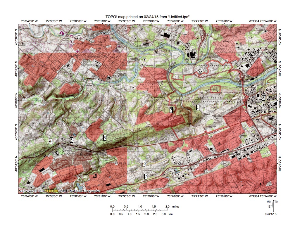
Figure 2: Valley Creek East is the stream identified with the number 6 and flows in an east-northeast direction on the Chester Valley floor before turning in a north direction to flow between Mount Joy (number 1) and Mount Misery (number 2) to join the Schuylkill River as a barbed tributary. The number 7 identifies Little Valley Creek, which is an east-northeast tributary to Valley Creek East. The number 8 identifies Trout Creek, which is one of several short streams draining the Chester Valley between Valley Creek East and the Schuylkill River. Numbers 3, 4, 5, identify some of the wind gaps on the Chester Valley north wall where south oriented water probably continued to flow into the Chester Valley after the reversal of Valley Creek East. United States Geological Survey map digitally presented using National Geographic TOPO software.
Valley Creek East (number 6 in figure 2) and its east-northeast oriented tributary Little Valley Creek (location 7 in figure 2) flow in roughly an east-northeast direction for some distance along the Chester Valley floor until near the Schuylkill River. Figure 2 shows how instead of flowing along the Chester Valley floor to join the Schuylkill River, Valley Creek East turns north and flows through a water gap between Mount Misery (location 2 in figure 2) and Mount Joy (location 1 in figure 2) to join the Schuylkill River as a barbed tributary. Trout Creek (location 8 in figure 2) is a much shorter stream draining the Chester Valley area nearest to the Schuylkill River. Valley Creek East is a barbed tributary because the Schuylkill River after being joined by south oriented Perkiomen Creek flows in a southwest and then southeast direction to join Valley Creek East and before turning to flow in an east-northeast direction. The north oriented Valley Creek East valley and the southwest and southeast oriented Schuylkill River segments could be considered southern extensions of the Perkiomen Creek valley. If so south oriented water from the Perkiomen Creek valley and perhaps from the Schuylkill River valley eroded the water gap as it flowed into the Chester Valley and then in a west-southwest direction along the Chester Valley floor to reach the south oriented East Branch Brandywine Creek valley. This interpretation means the east-northeast oriented Valley Creek East route on the Chester Valley floor originated as a west-southwest oriented flow route.

Figure 3: The East Branch Brandywine Creek flows in a south direction from the northwest map corner across the Chester Valley and then in a narrow southeast oriented valley through the South Valley Hills. Valley Creek West flows in a southwest direction on the Chester Valley floor to just south of the brown mined area and then turns to flow in a south direction through a narrow valley cut in the South Valley Hills to join the East Branch Brandywine Creek near the south edge of figure 3. United States Geological Survey map digitally presented using National Geographic TOPO software.
To verify the former west-southwest oriented flow along the Chester Valley floor we need to look at what Valley Creek West does as it approaches south oriented East Branch Brandywine Creek. Figure 3 (northwest corner) illustrates the East Branch Brandywine Creek flowing from hills north of the Chester Valley and then across the Chester Valley into the South Valley Hills where it turns to flow in a southeast direction. Valley Creek West can be seen flowing in a west-southwest and southwest direction on the Chester Valley floor to just south of the brown mined area where it turns in a south direction to flow in a narrow valley through the South Valley Hills to join the East Branch Brandywine Creek near the south edge of figure 3. The drainage divide between Valley Creek West and the East Branch Brandywine Creek on the Chester Valley floor is at least 200 feet lower than South Valley Hills elevations surrounding the Valley Creek West valley, yet Valley Creek West ignores the lower Chester Valley floor route and turns to flow through the South Valley Hills. Such behavior can be explained by west-southwest oriented flow that occurred at a time when the regional valleys, including the East Brandywine Creek, Schuylkill River, and Chester Valleys, were beginning to be eroded.
Finally the deep erosion of the diverging and converging valleys seen in figures 1, 2 and 3 could only have occurred if immense volumes of south or southwest oriented water was flowing across the region and was being captured in sequence by headward erosion of deep south oriented valleys. In the case of valleys seen in figures 1, 2, and 3, headward erosion of the south-oriented East Branch Brandywine Creek valley first captured south and southwest oriented flow that was flowing from areas north and northeast of the present day Chester Valley and that was then being channeled in a west-southwest direction along what was then a slightly lower channel on the Chester Valley alignment. Headward erosion of the East Branch Brandywine Creek valley across the Chester Valley alignment significantly lowered the local base level, which permitted the west-southwest oriented flow to lower the Chester Valley floor headward in an east-northeast direction.
Lowering of the Chester Valley floor ended south oriented floodwater spillage from what had been a shallow Chester Valley channel into what was then the actively eroding Chester Creek valley. However west-southwest oriented flow was still moving along what is now the South Valley Hills crest and that flow was captured in sequence (from west to east) by headward erosion of the south oriented Chester Creek headwaters valleys seen in figure 1 and also in sequence (from west to east) by the north oriented Valley Creek West and Valley Creek East tributaries and headwaters also seen in figure 1. This erosion occurred prior to Schuylkill River valley headward erosion.
Headward erosion of the Schuylkill River valley occurred next while lowering of the Chester Valley floor (which was occurring in an east-northeast direction) was still progressing toward the present day Schuylkill River valley location. At that time significant flow into the lowering west-southwest oriented Chester Valley channel was moving in a south direction from the Perkiomen Creek valley between Mount Joy and Mount Misery as seen in figure 2 and then in a west-southwest direction toward the newly eroded and south oriented Valley Creek West and East Branch Brandywine Creek valleys. When the much deeper Schuylkill River valley beheaded the south oriented channel between Mount Joy and Mount Misery it caused a flow reversal to create the east-northeast and north oriented Valley Creek East route and the drainage divide between Valley Creek East and Valley Creek West. Apparently large volumes of water was still spilling into the Chester Valley from the region to the north (suggesting the deep Schuylkill River valley and its tributary valleys were still eroding headward in the region) to feed the reversed flow route so as to further erode the Valley Creek East valley into the Chester Valley floor.

Leave a comment