
Neshaminy Creek “meanders” in an east direction north of Warrington Township while Little Neshaming Creek flows in an east, southeast, and east direction through southern Warrington Township. Mill Creek is a significant northeast oriented Neshaminy Creek tributary originating in Warrington Township. The Neshaminy Creek-Little Neshaminy Creek drainage divide elevation northeast of Montgomeryville along the Montgomery-Bucks County line has an elevation greater than 500 feet, but decreases to less than 340 feet south of the Mill Creek valley in the Warrington Township Twin Oaks Park area before eventually rising to more than 420 feet at Warrington. This significant sag in the drainage divide elevation was eroded by massive and prolonged southwest oriented floods moving from New Jersey to the Chester valley and which headward erosion of the West and East Branch Brandywine Creek valleys, Schuylkill River valley, and Wissahickon Gorge headward erosion captured in sequence prior to headward erosion of the Litlle Neshaminy Creek valley and the Neshaminy Creek valley.
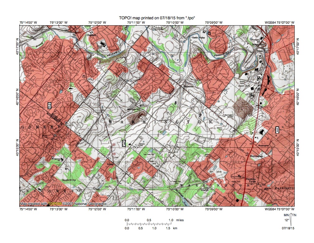
Figure 1: Neshaminy Creek-Little Neshaminy Creek drainage divide area in Warrington Township, Bucks County, Pa. See text for detailed description. United States Geological Survey map digitally presented using National Geographic TOPO software.
Figure 1 illustrates the Neshaminy Creek-Little Neshaminy Creek drainage divide area in Warrington Township. Neshaminy Creek “meanders” in an east direction near the north edge of the map. East of figure 1 Neshaminy Creek turns to flow in a southeast and south direction and eventually joins a southwest oriented Delaware River segment. Little Neshaminy Creek flows in an east direction near the south edge of the west half of figure 1 before turning to flow in a southeast direction to the south edge of figure 1. South and east of figure 1 Little Neshaminy Creek eventually joins Neshaminy Creek. Location 1 is in Warrington and is at an elevation of more than 420 feet. Location 2 has an elevation of more than 500 feet (and is northeast of unseen Montgomeryville). Location 3 is slightly west of Twin Oaks Park where the drainage divide elevation is less than 340 feet.
Mill Creek is located north of location 3 and flows in a northeast direction to join a north oriented Neshaminy Creek segment. Several other northeast-oriented Neshaminy Creek tributaries are seen in figure 1 and while not seen in figure 1 most Neshaminy Creek tributaries from the north begin as southwest oriented streams and join Neshaminy Creek as barbed tributaries. Note how a Little Neshaminy Creek tributary south of location 3 begins with a southwest orientation and then turns to flow in a south-southeast direction to join east oriented Little Neshaminy Creek. Note northeast oriented tributaries joining the east oriented Little Neshaminy Creek segment from the south and southwest oriented tributaries joining the southeast oriented segment from the northeast. The northeast and southwest orientations of the Neshaminy and Little Neshaminy Creek tributaries seen in figure 1 is related to underlying geologic structures and also the direction of the prolonged and massive flood movements, which were shaped by the geologic structures.
Floodwaters that carved the drainage divide sag seen between locations 1 and 2 in figure 1 came from the northeast and probably were derived from a melting continental ice sheet. The floodwaters initially flowed to and then along the Chester Valley to the present day Susquehanna River drainage basin before being captured in sequence by headward erosion of the West Brandywine Creek, East Brandywine Creek, Schuylkill River, and Wissahickon Creek valleys. Subsequently Little Neshaminy Creek valley headward erosion captured the southwest oriented flood flow prior to headward erosion of the Neshaminy Creek valley. The “meanders” seen in the Neshaminy Creek reflect where valley headward erosion occurred along former flood flow channels or in some cases along flood flow channels where the flow direction had been reversed by headward erosion of the much deeper Neshaminy Creek valley. The northeast oriented tributary valleys were also eroded by reversed flood flow moving to the much deeper Neshaminy and Little Neshaminy Creek valleys. Southwest oriented flood flow to the Neshaminy Creek valley ended when headward erosion of the south and southeast oriented Delaware River valley to the east and northeast of figure 1 captured all of the floodwaters.

Leave a comment