
Crum Creek and Darby Creek both originate in the same region near Paoli and Berwyn just south of the Chester Valley south rim and diverge slightly before flowing in southeast and south-southeast directions to join the southwest oriented Delaware River at almost the same location. Both streams are joined by northeast oriented barbed tributaries from the southwest and by southwest oriented tributaries from the northeast. Further shallow notches along the Crum Creek-Darby Creek drainage divide link the northeast oriented Darby Creek tributary valleys with the southwest oriented Crum Creek tributary valleys. The shallow notches linking the northeast oriented Darby Creek tributary valleys with the southwest oriented Crum Creek tributary valleys are particularly noticeable in the region between the two streams just north of Newtown Square.
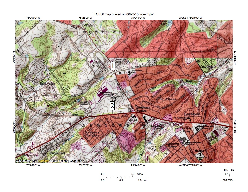
Figure 1: Crum Creek-Darby Creek drainage divide area near Newtown Square. See text for detailed description. United States Geological Survey map digitally presented using National Geographic TOPO software.
Figure 1 illustrates the region between Crum Creek and Darby Creek near Newtown Square. Crum Creek can be seen flowing in a south direction near the west edge of figure 1. Darby Creek flows in a southeast direction across the northeast corner of figure 1. Note how Crum Creek tributaries seen in figure 1 generally flow in southwest oriented valleys and how Darby Creek tributaries seen in figure 1 generally flow in northeast oriented valleys. The numbers 1 and 2 along the divide between the Crum Creek drainage basin and the Darby Creek drainage basin mark locations of shallow notches linking northeast oriented Darby Creek tributary valleys with southwest oriented Crum Creek tributary valleys. The notch at location 1 has a floor elevation of between 430 and 440 feet and the notch at location 2 has a floor elevation of 410 and 420 feet. High points seen along the drainage divide, and on ridges between the Crum and Darby Creek tributary valleys both north and south of the two notches rise to more than 480 feet (with 480-foot high hills located just south of figure 1). These high points suggest the notches are 40-70 feet deep.
The web applications map on the Pennsylvania Geologic Survey website shows bedrock in the region to be various types of gneiss. The northeast-southwest orientation of the Crum and Darby Creek valleys may in some cases be related to a northeast-southwest orientation of these metamorphic rock units. However, not all tributary valley segments are oriented in the same direction and some definitely cut across the bedrock structure, as do the deeper Crum Creek and Darby Creek trunk stream valleys. While the bedrock structure may have played a role in shaping the tributary valley orientations probably another factor was also involved. The most likely explanation for the northeast-southwest orientation of the Crum Creek and Darby Creek tributary valleys seen in figure 1 is that prior to headward erosion of the Crum Creek and Darby Creek valleys the region was crossed by massive and prolonged southwest oriented floods.
The southwest oriented floods scoured the region and were flowing in diverging and converging shallow southwest oriented channels, which eroded along zones of weakness created by the bedrock structure. Headward erosion of the deeper south oriented Crum Creek valley (from the much deeper and newly eroded Delaware River valley) captured the southwest oriented flood flow and floodwaters flowing into the newly eroded Crum Creek valley eroded southwest oriented Crum Creek tributary valleys. Next headward erosion of the deep Darby Creek valley beheaded southwest oriented flood flow channels to the newly eroded Crum Creek valley. Floodwaters on northeast ends of the beheaded flood flow channels reversed flow direction to the erode northeast oriented Darby Creek tributary valleys. Because the flood flow channels were beheaded in sequence from south to north and because the flood flow channels were interconnected floodwaters in a newly beheaded and reversed flood flow channel could capture flood flow from yet to be beheaded flood flow channels further to the north. Such captures of yet to be beheaded flood flow provided enough water to the newly reversed flood flow channels so as to erode the deep northeast oriented Darby Creek tributary valleys seen in figure 1.

Leave a comment