
The Neshaminy Creek drainage route just downstream from Neshaminy Falls exhibits an intriguing elbow of capture seen in figure 1 below. Neshaminy Creek flows in a south, southwest and south direction from location 1 to location 2 and then turns to flow in a northeast direction before turning again to flow in a southeast direction to location 3. The elbow of capture at location 2 is here referred to as the Neshaminy Creek Elbow of Capture. An east and northeast oriented tributary flowing from near Trevose at location 4 joins Neshaminy Creek at location 2 as a barbed tributary. A question that needs answering is why does Neshaminy Creek make the northeast oriented jog seen in figure 1?
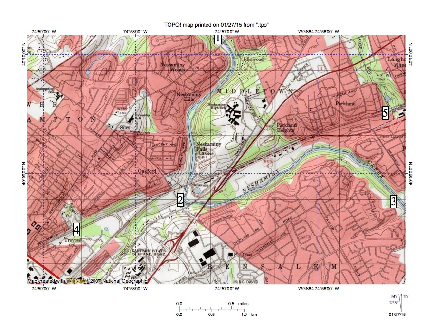
Figure 1: Neshaminy Creek flows from location 1 to location 2 and then to location 3. United States Geological Survey map digitally presented using National Geographic TOPO software.
The northeast oriented Neshaminy Creek segment and its east and northeast oriented tributary flow in a linear valley that extends in figure 1 from location 4 to location 5 and that can be traced in a west-southwest direction to Jenkintown (the SEPTA West Trenton Regional Rail line between Jenkintown and Neshaminy Falls is located in the linear valley). The Somerton-Huntingdon Valley Through Valley and the Meadow Brook Through Valley essays on this website describe western segments of this linear valley between Poquessing Creek and Pennypack Creek and between Pennypack Creek and Tacony Creek. The linear valley probably is related to a geologic feature such as a fault line (the Pennsylvania Geological Survey web application map shows the valley located along the boundary between two different metamorphic rock units, although both units should be resistant to erosion and are resistant to erosion both north and south of the boundary).
At the time headward erosion of the Neshaminy Creek valley into the figure 1 map region occurred the Delaware River valley east of figure 1 and the linear valley did not exist. At that time the entire region was as high or higher than the highest elevations seen in the figure 1 map area today (more than 200 feet in terms of today’s elevations, although at that time sea level may have been significantly lower) and the present day valleys did not exist. Also at that that time massive and prolonged southwest oriented floods were moving in diverging and converging flood flow channels across the region. Floodwaters came from east and north of the present day south oriented Delaware River valley segment found east of figure 1 (after flowing in a southeast and south direction east of figure 1 the Delaware River turns to flow in a southwest direction to reach Philadelphia).
When the deep Neshaminy Creek valley eroded headward into the high-level surface that once existed throughout the figure 1 map region the southwest oriented floodwaters were eroding the deep southwest-oriented Delaware River valley segment south of figure 1. The deep south-oriented Neshaminy Creek valley eroded headward from that actively eroding southwest-oriented Delaware River valley to capture southwest oriented flood flow moving north of the actively eroding Delaware River valley. In the case of the Neshaminy Falls elbow of capture the actively eroding and deep south-oriented Neshaminy Creek valley beheaded a major west-southwest oriented flood flow channel (perhaps where flood flow was concentrated along a zone of easily eroded bedrock) and water on the northeast end of that flood flow channel reversed direction to flow in a northeast direction to reach the much deeper Neshaminy Creek valley.
The northeast oriented tributary valley draining to the Neshaminy Creek valley at location 2 was eroded when a southwest oriented flood flow channel converging with the linear flood flow channel at Trevose was captured by the reversed flow so as to be redirected in a northeast direction from location 4 to location 2. However headward erosion of the deep Neshaminy Creek valley beheaded the southwest oriented flood flow channel and then eroded headward along that flood flow channel to erode the southwest oriented Neshaminy Creek valley segment north of Neshaminy High School. The deep Neshaminy Creek valley then eroded headward in a northwest direction to capture a major west-southwest oriented flood flow channel just north of figure 1 (see Neshaminy Creek Water Gap and Elbows of Capture near Langhorne essay on this website).
Finally southwest oriented flood flow across the region was further beheaded when the deep Delaware River valley turned from eroding headward in a northeast direction along a southwest oriented flood flow channel to eroding headward in a north and northwest direction across the southwest oriented flood flow channels. Headward erosion of the deep southeast and south oriented Delaware River valley east of figure 1 ended all southwest oriented flood flow to the newly eroded Neshaminy Creek valley and created the Neshaminy Creek drainage basin as we see it today.

Leave a comment