
The Schuylkill River flows in a southeast direction into Philadelphia and just after flowing under the Roosevelt Avenue Bridge makes an abrupt turn to flow in a southwest direction. After flowing in a southwest direction the Schuylkill River flows under the Columbia Bridge and just west of the East Park Reservoir makes another abrupt turn to flow again in a southeast direction. These abrupt changes in flow direction are elbows of capture. Additional Schuylkill River elbows of capture can be seen further downstream in the City of Philadelphia as well as at numerous upstream locations. Urban development has complicated interpretations of the Philadelphia elbows of capture, although based on what evidence remains and also on evidence from north of the city a history of these two elbows of capture can be suggested.
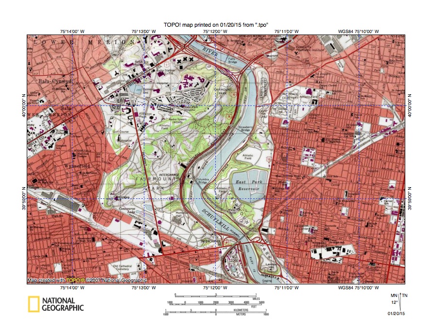
Figure 1: Schuylkill River elbows of capture. The Roosvelt Avenue Bridge is located near the map north center edge. The Columbia Bridge is located west of the East Park Reservoir. United States Geological Survey map digitally presented using National Geographic TOPO software.
At the time Schuylkill River valley erosion began elevations to the north of the Columbia Bridge Elbow of Capture were at least as high or higher than the present day highest elevations in Chestnut Hill and Upper Roxborough (more than 400 feet). Elevations south of the Columbia Bridge Elbow of Capture may have gradually decreased, although they were probably greater than elevations today. In other words, the Schuylkill River valley eroded headward into and across a pre-Schuylkill River landscape surface that no longer exists.
What was most important about pre-Schuylkill River valley landscape at the time Schuylkill River valley headward erosion began was that massive and prolonged southwest oriented floods were moving across the Philadelphia region and continued to flow across the region as the Schuylkill River valley eroded headward. Floodwaters were probably flowing in anastomosing complexes of shallow diverging and converging channels. Urban development in the City of Philadelphia has obscured much of the evidence for these southwest oriented flow channels, although further north aligned drainages crossing the Wissahickon Creek drainage basin are relics of the flood formed southwest oriented diverging and converging channels.
The deep Schuylkill River valley eroded headward into the high-level early landscape to capture the massive southwest oriented flood flow. The captured floodwaters in turn enabled the deep Schuylkill River valley and its tributary valleys to erode headward even further so as to capture more of the southwest oriented flood flow. Southeast oriented valley segments were formed as the Schuylkill River valley and tributary valleys eroded headward across southwest oriented flood flow channels while southwest oriented valley segments were formed as the Schuylkill River valley and tributary valleys eroded headward along captured southwest oriented flood flow channels.
With this background in place the Columbia Bridge Elbow of Capture can be explained. Headward erosion of the downstream southeast oriented Schuylkill River valley segment (from the Museum of Art to Columbia Bridge) was across southwest oriented flood flow while headward erosion of the upstream southwest oriented Schuylkill River valley segment (from Columbia Bridge to Roosevelt Avenue Bridge) was along a southwest oriented flood flow channel. That southwest oriented flood flow channel probably followed the present day Hunting Park Avenue route towards Olney and a present day southwest oriented Tacony Creek segment (between Cheltenham and Olney) and further east a short southwest oriented Pennypack Creek segment and was captured by headward erosion of the southeast oriented Schuylkill River valley segment.
The Roosevelt Avenue Bridge Elbow of Capture was created by a capture that took place when headward erosion of the south oriented Tacony Creek valley (from what at that time was a newly eroded southwest oriented Delaware River valley) captured the southwest oriented flow channel and ended all flow along the Olney-Hunting Park Avenue route to the actively eroding Schuylkill River valley. This Tacony Creek capture meant the Schuylkill River valley could no longer erode headward along the southwest oriented flow channel. Fortunately for the Schuylkill River future a southeast oriented tributary valley along the present day Schuylkill River alignment upstream from the Roosevelt Avenue Bridge had been eroding headward from the southwest oriented Schuylkill River valley segment and was capturing yet to be beheaded southwest oriented flood flow (that was moving in flood flow channels north of the actively eroding Tacony Creek valley head). That southeast oriented tributary valley captured enough southwest oriented flow to keep eroding headward and to become what is today the southeast oriented Schuylkill River valley segment upstream from the Roosevelt Avenue Bridge.

Leave a comment