
Wissahickon Creek has a relatively small drainage basin in southeastern Pennsylvania, but is located along the Schuylkill River-Delaware River drainage divide southern end and includes a well-known and picturesque gorge in northwest Philadelphia. The stream rises near Lansdale in Montgomery County and flows for approximately 23 miles in a south direction to reach northwest Philadelphia and the southeast oriented Schuylkill River. From its headwaters Wissahickon Creek flows across alternating bands of shale, siltstone, argillite and sandstone until flowing across the dipping carbonate and quartzite bedrock units in the Whitemarsh Valley before entering a seven-mile long gorge carved through an intensely folded complex of metamorphic and igneous rocks to reach the Schuylkill River. Today the Wissahickon Gorge is a National Natural Landmark maintained by Philadelphia’s Fairmount Parks System. Upstream from the Gorge suburban developments of various types cover much, but not all of the Wissahickon Creek drainage basin.
This essay uses topographic map evidence to illustrate, describe, and interpret significant landform features in each Wissahickon Creek drainage basin segment. The contour interval for maps illustrated here are in feet and for that reason this essay uses feet and miles for elevations and distances. Evidence illustrated and discussed here demonstrates that prior to Wissahickon Creek drainage basin erosion massive and prolonged southwest oriented floods moved across the entire region and headward erosion of the Wissahickon Creek valley systematically captured the southwest oriented flow and diverted the water more directly to what was at that time a newly eroded Schuylkill River valley. In the same way Pennypack Creek valley headward erosion to the east subsequently diverted southwest flow moving to the newly eroded southern half of the Wissahickon Creek drainage basin to what at that time was a newly eroded Delaware River valley, while Neshaminy Creek valley headward erosion later diverted southwest oriented flow moving to the newly eroded Pennypack Creek and Wissahickon Creek drainage basins to a point further upstream in the newly eroded Delaware River valley.
Probably one of the most interesting questions about the Wissahickon Creek drainage basin origin relates to the origin of northwest Philadelphia’s Wissahickon Gorge. Upstream from Philadelphia the Wissahickon Creek drainage basin is almost everywhere lower in elevation than the crest of the metamorphic and igneous complex ridge through which the Gorge has been eroded and numerous through valleys link the Wissahickon Creek drainage basin with adjacent drainage basins, especially to the west. Why did Wissahickon Creek erode a seven-mile long gorge through a high ridge when multiple lower routes existed? Or, if the alternate routes did not exist, how were the through valleys that now provide those alternate and lower elevation routes eroded? This essay attempts to answer those questions although in doing so raises additional questions that can only be answered with evidence from beyond southeast Pennsylvania.
Southwest oriented headwaters segment evidence
Wissahickon Creek originates east of Lansdale, Pennsylvania at an elevation of approximately 400 feet and its headwaters flow in a southwest direction for a distance of approximately 4 miles before reaching an elevation of approximately 300 feet where the stream turns to flow in a southeast direction through its first water gap. Wissahickon Creek headwaters (figure 1) are bounded on the north by the deeper northeast and east oriented headwaters of a West Branch Neshaminy Creek tributary and further to the north the West Branch Neshaminy Creek turns in a 200-foot deep valley from flowing in a south direction to flow in a northeast and east direction (figure 3). To the south of the southwest oriented Wissahickon Creek headwaters are northeast and east oriented headwaters of Little Neshaminy Creek, with Little Neshaminy Creek being a tributary of Neshaminy Creek. Many Neshaminy Creek headwaters seen in figure 3 are oriented in a southwest direction before they turn to flow in east or northeast directions. To the west of the southwest oriented Wissahickon Creek headwaters are southwest oriented headwaters of Towamencin Creek (figure 2), which flows to Skippack Creek and then Perkiomen Creek before reaching the Schuylkill River upstream from Wissahickon Creek. As seen in figures 1, 2, and 3 headwaters of many regional streams and tributaries are oriented in either southwest or northeast directions.
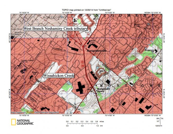
Figure 1: Wissahickon Creek flows from its headwaters to the map southwest corner. A West Branch Neshaminy Creek tributary flows in a northeast direction across the northwest corner of the map. Little Neshaminy Creek headwaters are near the map south center edge and flow in a northeast and east direction to the map east edge (slightly south of center). United States Geological Survey map presented using National Geographic TOPO software.
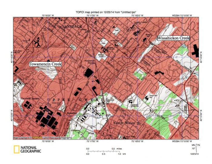
Figure 2: Relationship of southwest oriented Wissahickon Creek headwaters to southwest oriented Towamencin Creek headwaters. West of map Towamencin Creek flows to south and southwest oriented Skippack Creek, which then flows to south oriented Perkiomen Creek, which in turn flows to the southeast oriented Schuylkill River. Southwest oriented Towamencin Creek headwaters along with the southwest oriented Wissahickon Creek headwaters are relics of the southwest oriented drainage routes that once crossed the region. United States Geological Survey map presented using National Geographic TOPO software.
Southwest oriented Wissahickon Creek headwaters section discussion
The first Wissahickon Creek origin problem that needs to be solved is why do Wissahickon Creek headwaters flow in a southwest direction while adjacent Neshaminy Creek tributaries originating on either side of the Wissahickon Creek headwaters flow in a northeast direction? The fact these headwaters streams flow in southwest or northeast directions suggests they are flowing parallel to the strike of underlying dipping strata, which is probably supported by geological evidence and which will be seen throughout the Wissahickon Creek drainage basin. But, the strike of the dipping strata does not explain why Wissahickon Creek flows in a southwest direction and why adjacent Neshaminy Creek tributaries flow in the opposite direction. Such an arrangement is difficult to explain especially if random events, underlying strata, and local runoff were the only factors involved in determining the Wissahickon Creek and the Neshaminy Creek tributary headwaters valley orientations. Some additional factor must have been involved.
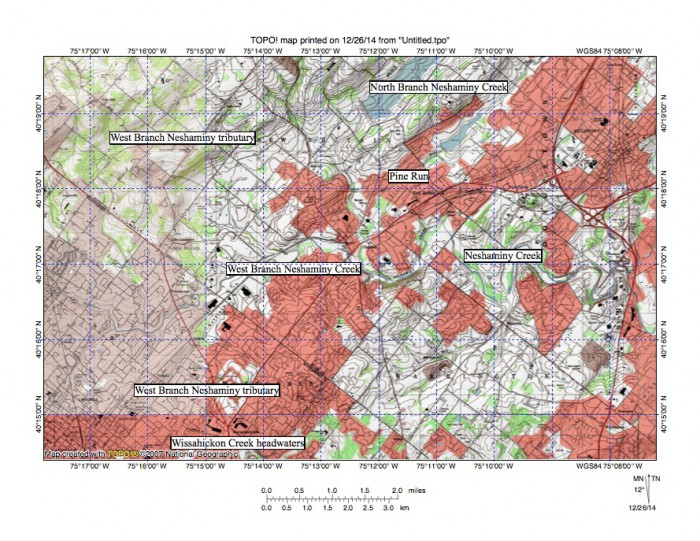
Figure 3: Reduced size topographic map illustrating Wissahickon Creek headwaters relationship to the Neshaminy Creek headwaters. The West Branch Neshaminy Creek flows in a south-southeast and then northeast and east direction from the map northwest corner to Chalfont, near the map center, where it joins the North Branch to form Neshaminy Creek. The northernmost marked West Branch tributary flows in a southwest direction to join east oriented West Branch Neshaminy Creek, while the southern marked West Branch tributary flows in a northeast direction. The North Branch Neshaminy Creek and its tributary Pine Run both flow in southwest directions before turning to flow in a south direction to join east-oriented Neshaminy Creek (which east of figure 2 turns to flow in a south- southeast direction to join the Delaware River). The southwest oriented North Branch Neshaminy Creek, Pine Run, and West Branch Neshaminy Creek tributary all provide evidence that headward erosion of the Neshaminy Creek valley captured multiple southwest-oriented channels. The northeast oriented West Branch Neshaminy Creek tributary shown was created by a reversal of flow on the northeast end of a beheaded southwest oriented flow channel. The southwest oriented Wissahickon Creek headwaters are a relic of southwest oriented drainage routes that preceded the present day drainage system. United States Geological Survey map presented using National Geographic TOPO software.
Figure 4: Elbows of capture where southwest oriented North Branch Neshaminy Creek and Pine Run turn to join the northeast oriented West Branch Neshaminy Creek and to form east oriented Neshaminy Creek, which east of figure 3 turns to flow in a south-southeast direction to join a southwest oriented Delaware River segment. United States Geological Survey map presented using National Geographic TOPO software.
Perhaps the most likely additional factor is the southwest oriented Wissahickon Creek and northeast oriented Neshaminy Creek tributary headwaters appear to be relics of what was once a southwest oriented complex of anastomosing channels that once crossed the entire region. Northeast oriented Neshaminy Creek and Neshaminy Creek tributary segments probably were formed by reversals of flow on the northeast ends of beheaded southwest oriented channels captured by headward erosion of the deeper south oriented Neshaminy Creek valley (further to the east). Elbows of capture seen in figures 3 and 4 where southwest oriented North Branch Neshaminy Creek, Pine Run, and West Branch Neshaminy Creek tributaries turn to flow in east and northeast directions further support the hypothesis that Neshaminy Creek valley headward erosion captured multiple southwest oriented flow channels. Headward erosion of the south and southeast oriented Neshaminy Creek valley also beheaded the channel supplying water to the southwest oriented Wissahickon Creek headwaters valley, but was not able to reverse the flow. However, capture of southwest oriented channels further to the north enabled the West Branch Neshaminy Creek valley to erode a deeper valley just north of the Wissahickon Creek headwaters. Further east headward erosion of the still deeper Delaware River valley eventually captured all flow in the southwest oriented anastomosing channels in sequence from south to north to end all southwest oriented flow across the Neshaminy Creek drainage basin. Numerous northeast oriented tributaries flowing to the southeast oriented Delaware River valley east of the Neshaminy Creek drainage basin provide evidence of reversals of flow on northeast ends of beheaded channels.
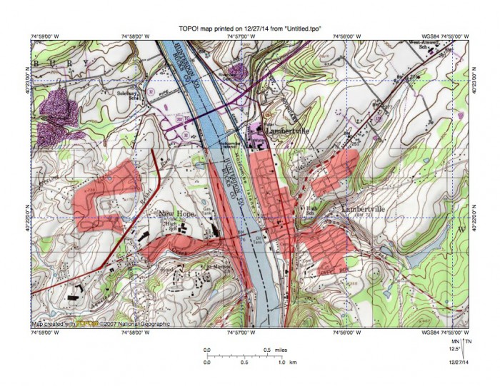
Figure 5: Delaware River valley at New Hope, PA and Lambertville, NJ. Note how tributary streams from the west flow in northeast directions to join the south oriented Delaware River as barbed tributaries while tributaries from the east flow in southwest directions. This evidence suggests the Delaware River valley eroded headward across multiple southwest oriented channels. United States Geological Survey map presented using National Geographic TOPO software.
Wissahickon Creek water gap near North Wales: evidence
The Wissahickon Creek headwaters enter a southwest oriented 50-100 foot deep valley and flow for approximately 4 miles before turning to flow in a south-southeast direction through a 120-foot deep water gap near North Wales. The water gap is cut across a ridge that exceeds 420 feet in elevation both to the northeast and to the southwest while the Wissahickon Creek elevation in the water gap is less than 300 feet. This water gap is relatively insignificant when compared with water gaps in the folded Appalachian, however this relatively minor gap probably fits the water gap definition. What can be determined from the topographic map evidence is Wissahickon Creek has eroded a 120-foot deep valley across an erosion resistant rock unit. Also of significance is the southwest oriented Wissahickon Creek valley on the water gap upstream side is linked by a shallow through valley with the southwest oriented headwaters of Zacharias Creek, with Zacharias Creek flowing in a southwest and west direction to join south and southwest oriented Skippack Creek, which flows to south oriented Perkiomen Creek, which in turn flows to the southeast oriented Schuylkill River. The Zacharias Creek headwaters valley and gap linking those headwaters with the southwest oriented Wissahickon Creek headwaters valley help define the ridge through which the water gap has been eroded. The Wissahickon Creek flow direction changes at the water gap location from southwest to south-southeast.
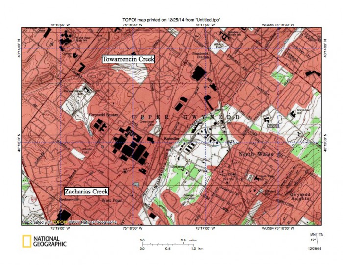
Figure 6: Wissahickon Creek water gap near North Wales is located near center of map. Wissahickon Creek flows in a south-southwest and south-southeast direction from the map north center edge to the water gap and south of the water gap turns to flow in an east direction to near the map southeast corner. Southwest oriented Zacharias Creek headwaters are located in the map northwest corner, with Zacharis Creek flowing to south and southwest oriented Skippack Creek, which flows to Perkiomen Creek, which in turn flows to the Schuylkill River. Note ridge extending from the map southwest corner to the map northeast corner through which Wissahickon Creek has eroded its North Wales water gap. Unnamed southwest oriented tributaries join Wissahickon Creek south of the water gap. United States Geological Survey map presented using National Geographic TOPO software.
Wissahickon Creek North Wales water gap: discussion
The Wissahickon Creek North Wales water gap provides evidence that headward erosion of the Wissahickon Creek valley captured flow from what was once a southwest oriented channel on the southwest oriented Wissahickon Creek headwaters and southwest oriented Zacharias Creek headwaters alignment. The question that must be answered is how did this capture occur? The ridge through which the water gap is eroded forms an erosion resistant barrier that, had a well-defined valley on the Wissahickon-Zacharias Creek headwaters alignment existed would have been very difficult to breach. While it could be argued the water gap may have been eroded along a fault line or similar zone of geologic weakness such an explanation does not adequately explain how a local south-southeast oriented stream was able to erode headward for almost one half mile across what is today a 120-foot high ridge. Most likely the stream capture took place at a time when water was flowing in both a southwest direction to what was an actively eroding Zacharias Creek valley and in a south- southeast direction to what was an actively eroding Wissahickon Creek valley. For reasons not apparent from evidence in the water gap region water flowing to the Wissahickon Creek valley was able to erode its valley deeper than water flowing to the Zacharias Creek valley. Both drainage routes lead to the Schuylkill River valley, with the Wissahickon Creek valley providing a shorter route. Probably the shorter route to the Schuylkill valley provided by the Wissahickon Creek valley played an important role in this Wissahickon Creek stream capture, although other factors may have also been important.
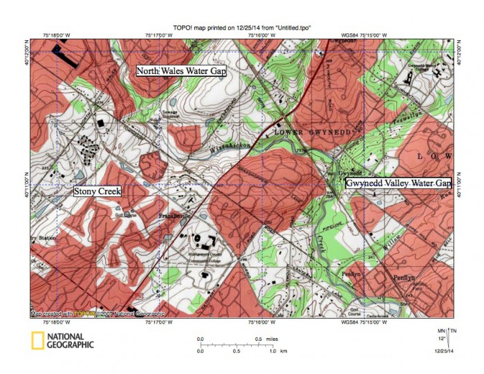
Figure 7: Wissahickon Creek valley showing the North Wales and Gwynedd Valley water gaps. Downstream from the North Wales water gap Wissahickon Creek flows in an east direction before turning in a south direction to flow through the Gwynedd Valley water gap. Southwest oriented Trewellyn Creek and Willow Run flow on either side of the eroded ridge, which is approximately 350 feet high or about 100 feet higher than the Wissahickon Creek valley floor. Headwaters of southwest oriented Stony Creek can be seen on the northwest side of the ridge west of the Wissahickon Creek valley. Stony Creek flows to the Schuylkill River. The gap linking the Stony Creek headwaters with the Wissahickon Creek valley has an elevation of approximately 300 feet and is about 50 feet lower in elevation than the ridge crest. United States Geological Survey map presented using National Geographic TOPO software.
Wissahickon Creek water gap at Gwynedd Valley: evidence
After flowing in a south-southeast direction through its North Wales water gap Wissahickon Creek is joined by an unnamed southwest oriented tributary and then turns to flow in an east direction to reach its next water gap at Gwynedd Valley. Some observers might question whether the Gwynedd Valley gap is a true water gap, although for purposes of this essay it is treated as a water gap. Opposite the point where an unnamed southwest oriented tributary joins Wissahickon Creek a shallow through links the Wissahickon Creek valley with the southwest oriented Stony Creek headwaters, with Stony Creek eventually turning in a south direction to join the Schuylkill River at Norristown. Today the Wissahickon Creek valley floor is approximately 50 feet lower than the through valley defined by the unnamed southwest oriented Wissahickon Creek tributary and the southwest oriented Stony Creek headwaters. The Wissahickon Creek southwest valley wall notch marks the location of a former southwest oriented flow route. The unnamed southwest oriented Wissahickon Creek tributary headwaters are also linked by a shallow through valley with the northeast oriented Little Neshaminy Creek headwaters. At Gwynedd Valley Wissahickon Creek has a floor elevation of approximately 250 feet where it flows through the 100-foot deep water gap. Southwest oriented Trewellyn Creek also joins Wissahickon Creek at Gwynedd Valley where Wissahickon Creek turns to flow in a south, southeast and south direction. Willow Run and an unnamed southwest oriented tributary flow in southwest directions to join the downstream Wissahickon Creek segment in the Pennlyn area (a short east oriented tributary, also named Willow Run joins Wissahickon Creek just south of the Cedarbrook Country Club, which is located just west of Pennlyn).
Wissahickon Creek water gap at Gwynedd Valley: discussion
The Wissahickon Creek water gap at Gwynedd Valley provides evidence that Wissahickon Creek valley headward erosion captured a southwest oriented flow channel located on the present day southwest oriented Stony Creek headwaters alignment. The question that must be answered is how did this capture occur? The northeast to southwest oriented ridge through which the water gap has been eroded is probably composed of more erosion resistant bedrock than the bedrock on either side. As in the case of the North Wales water gap the evidence strongly suggests southwest oriented flow existed prior to headward erosion of the Wissahickon Creek valley. This flow was probably moving on a surface with an elevation equivalent to the ridge tops today with water for at least a period of time moving to both of what were at that time actively eroding Stony Creek and Wissahickon Creek valleys. In time Wissahickon Creek valley headward erosion was able to capture all southwest oriented flow, which resulted in the capture event that created the Gwynedd Valley water gap. The Stony Creek and the Wissahickon Creek valleys both eventually drain to the Schuylkill River, although again the Wissahickon Creek valley provides a shorter route, which may explain why Wissahickon Creek valley headward erosion was able to behead the southwest oriented Stony Creek headwaters valley.
Wissahickon Creek water gap at Ambler: evidence
Downstream from Gwynedd Valley Wissahickon Creek flows in a south and then southeast direction before flowing through another water gap in the Ambler region. The ridge forming this Ambler water gap is defined on its southeast side by northeast oriented Prophecy Creek, which joins Wissahickon Creek as a barbed tributary. A short unnamed northeast oriented Wissahickon Creek tributary is also located just south of Prophecy Creek and another short east-northeast oriented tributary is located further to the south. These northeast-oriented Wissahickon Creek tributaries are barbed tributaries in that they flow in the opposite direction of the stream they join and they provide evidence of reversals of flow on the northeast ends of beheaded southwest oriented flow channels. Three unnamed southwest oriented tributaries join Wissahickon Creek in the Ambler region and help define the ridge on the northeast side of Wissahickon Creek. The floor of Wissahickon Creek as it flows through its Ambler water gap has an elevation of approximately 180 feet while ridge elevations on either side of the water gap exceed 300 feet, meaning the water gap is approximately 120 feet deep at its upper end. The northeast oriented Prophecy Creek headwaters valley is linked by a shallow through valley in the Wing Field and Five Points area with southwest and south oriented headwaters of southwest and south oriented Plymouth Creek, which joins the Schuylkill River near Conshohocken. Shallow through valleys link the unnamed southwest oriented Wissahickon Creek tributary valleys with the short northeast oriented Pennypack Creek headwaters valley, which then turns to drain in an east-southeast direction before turning to drain in a south- southeast and south direction to eventually join the Delaware River. Downstream from the Ambler water gap Wissahickon Creek flows in a southeast direction to near the Germantown Academy at Fort Washington where Wissahickon Creek turns to flow for a short distance in a southwest direction before turning to flow in a south direction through a water gap cut between Militia Hill and Fort Hill in the Fort Washington State Park area.
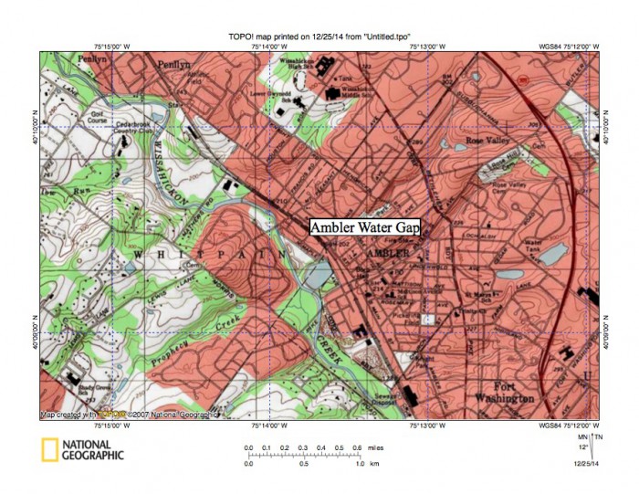
Figure 8: Wissahickon Creek flows in a southeast direction across low southwest to northeast oriented ridges in the Ambler region. Northeast oriented tributaries, including Prophecy Creek, from the southwest join Wissahickon Creek as barbed tributaries while southwest oriented tributaries flow to Wissahickon Creek from the northeast. The northeast and southwest orientation of tributaries in the Ambler region provide evidence the Wissahickon Creek valley eroded headward across multiple southwest oriented flow channels. United States Geological Survey map presented using National Geographic TOPO software.
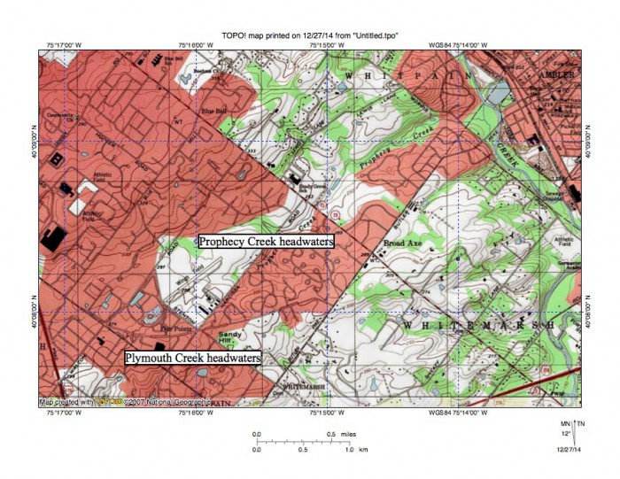
Figure 9: A shallow northeast to southwest oriented valley with an elevation of slightly less than 300 feet in the Wing Field area links the northeast oriented Prophecy Creek headwaters valley with the southwest oriented Plymouth Creek headwaters. Prophecy Creek flows to southeast oriented Wissahickon Creek as a barbed tributary. Much deeper valleys with elevations of slightly more than 200 feet link the Wissahickon Creek valley with Plymouth Creek are located just south of figure 9. United States Geological Survey map presented using National Geographic TOPO software.
Wissahickon Creek water gap at Ambler: discussion
Some observers may question whether the Ambler water gap is really a water gap and the Ambler water gap could also be viewed as being two or more closely associated water gaps, although for purposes of this discussion it will be treated as a single water gap. What is significant in the Ambler region is the 100-200 foot deep Wissahickon Creek valley has eroded headward across what had been southwest oriented channels supplying water to what was at that time the actively eroding Plymouth Creek valley. Again the problem arises as to how the Wissahickon Creek valley was able to capture flow from southwest oriented channels. The capture could only have been possible if at least some of the southwest oriented flow was also moving to the actively eroding Wissahickon Creek valley. In other words, the actively eroding Wissahickon Creek valley and the actively eroding Plymouth Creek valley were at one time competing with each other to capture the southwest oriented flow. The Wissahickon Creek valley again provided the shorter route to the Schuylkill River valley and for that reason was able to eventually capture all of the southwest-oriented flow. But, shortly thereafter the southwest oriented flow was captured and the flow channels were beheaded by headward erosion of Pennypack Creek valley further to the east. The northeast oriented Wissahickon Creek barbed tributaries were created by reversals of flow on the northeast ends of beheaded southwest oriented flow channels. The fact that Prophecy Creek has eroded a significant valley suggests reversed flow on the Prophecy Creek alignment was able to capture yet to be beheaded flow moving in channels north and west of the actively eroding Wissahickon Creek valley head. Evidence in the Ambler region argues for multiple southwest oriented channels, suggesting large volumes of water were moving in a southwest direction across the entire region in what was probably a large-scale anastomosing channel complex. This evidence suggests headward erosion of the Wissahickon Creek valley and adjacent valleys occurred during an immense and prolonged southwest oriented flood, which was coming from north and east of the present day Delaware River valley.
Water gaps at and near Fort Washington State Park: evidence
Wissahickon Creek water gap is located between Militia Hill and Fort Hill in the Fort Washington State Park area. Militia Hill, Fort Hill, and Camp Hill are erosional residuals left after the erosion of an east-northeast oriented quartzite ridge. Today these erosional residuals rise to elevations of 340 feet or more, although Fort Hill is lower. In the Fort Washington water gap area the Wissahickon Creek valley floor has an elevation of less than 150 feet. Militia Hill is located west of Wissahickon Creek with Fort Hill to the east. Camp Hill is located east of Fort Hill and Sandy Run flows in a west direction from Roslyn along the south side of the Camp Hill ridge before turning in a north direction to flow in a north direction through its water gap, which separates Camp Hill from Fort Hill. In other words Wissahickon Creek flows in a south direction through its Fort Washington water gap while Sandy Run flows in a north direction through its adjacent water gap. North of its water gap Sandy Run is joined by unnamed southwest oriented tributaries, which flow along the Camp Hill north flank, and then turns to flow in a west direction to join Wissahickon Creek.
Sandy Run has an elevation of approximately 160 feet where it flows between Fort Hill and Camp Hill. The Militia Hill ridge elevation reaches 340 feet, Fort Hill reaches 240 feet, and the Camp Hill ridge elevation exceeds 350 feet. Sandy Run headwaters and headwaters of the Sandy Run tributaries are all linked by shallow through valleys with the south oriented Pennypack Creek valley to the east. West of Wissahickon Creek a south and southeast oriented Wissahickon Creek tributary has eroded a 120-foot deep water gap across the west end of Militia Hill at Lancasterville. Still further to the west the George Washington Memorial Park is located in a valley that links the Wissahickon Creek valley north of the Militia Hill ridge with the southwest oriented Plymouth Creek valley, which drains to the Schuylkill River. While somewhat complex, this valley on the north side of Militia Hill provides a route from the Wissahickon Creek valley to the Plymouth Creek valley 50 or more feet lower in elevation than elevations surrounding the deep Wissahickon Gorge further to the south.
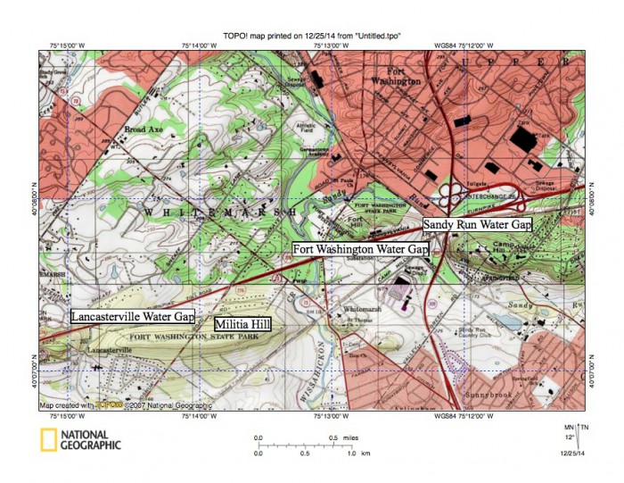
Figure 10: A shallow northeast to southwest oriented valley with an elevation of slightly less than 300 feet in the Wing Field area links the northeast oriented Prophecy Creek headwaters valley with the southwest oriented Plymouth Creek headwaters. Prophecy Creek flows to southeast oriented Wissahickon Creek as a barbed tributary. Much deeper valleys with elevations of slightly more than 200 feet link the Wissahickon Creek valley with Plymouth Creek are located just south of figure 9. United States Geological Survey map presented using National Geographic TOPO software.
Wissahickon Creek water gaps at and near Fort Washington State Park: discussion
The Wissahickon Creek water gap near Fort Washington State Park, the adjacent Sandy Run water gap east of Fort Hill, and the unnamed Wissahickon Creek tributary water gap at the Militia Hill west end provide a more complex set of evidence than seen in the previously discussed Wissahickon Creek water gaps. The underlying bedrock has changed from dipping shale and sandstone layers to carbonate and quartzite units. The ridge of which Militia Hill, Fort Hill, and Camp Hill are components is underlain by quartzite while carbonate units underlie the surrounding lower region. Wissahickon Creek drainage basin erosion began in this area as water flowed in a southwest direction across the present day Pennypack Creek drainage basin to and along the north side of the dipping quartzite bedrock unit now forming Camp Hill and reached the actively eroding Sandy Run water gap between Camp Hill and Fort Hill. South of that water gap the water was joined by southwest oriented flow that was eroding a channel on the south side of what is now the Camp Hill quartzite bedrock ridge. The combined flow then moved south through Sunnybrook before turning east to reach the present day Wissahickon Creek valley. At the same time water flowing south (along the present day Wissahickon Creek alignment) was being split in the Fort Hill area with some water continuing south along the present day Wissahickon Creek route to erode the water gap between Militia Hill and Fort Hill while some of the flow was moving to the actively eroding Sandy Run water gap between Fort Hill and Camp Hill. In other words the Sandy Run water gap was eroded by south oriented flow, some of which diverged from the evolving Wissahickon Creek channel and then further to the south converged with Wissahickon Creek channel, which means the two adjacent water gaps provide evidence of two south oriented diverging and converging flow channels.
As the Sandy Run and Wissahickon Creek water gaps were being eroded Pennypack Creek valley headward erosion beheaded all flow to Sandy Run and its tributaries while southwest oriented flow channels located north of the actively eroding Pennypack Creek valley head continued to supply water to the actively evolving Wissahickon Creek drainage basin (further upstream). As a result the water gap between Militia Hill and Fort Hill was eroded deeper than the Sandy Run water gap. The deeper Wissahickon Creek channel between Militia Hill and Fort Hill then caused a reversal of flow through the Sandy Run water gap so today Sandy Run turns to flow north through the water gap to reach Wissahickon Creek rather than flowing south and west as it once did. As the Sandy Run and Wissahickon Creek water gaps were being eroded water was also being channeled along the north side of Militia Hill to reach the actively eroding Plymouth Creek valley to create a channel on the Militia Hill north flank. Headward erosion of an unnamed south and southeast oriented Wissahickon Creek tributary valley captured this flow, but before it eroded much further north the southwest oriented flow along the Militia Hill north flank was beheaded when the deeper Wissahickon Creek valley eroded north (between Militia Hill and Fort Hill). This interpretation requires immense quantities of water to have been moving across the region first in a southwest direction and then being captured in sequence by headward erosion of the much deeper south oriented Wissahickon Creek valley and subsequently by the Pennypack Creek valley. Otherwise there is no logical explanation for the present day north oriented Sandy Run water gap being adjacent to the south oriented Wissahickon Creek water gap.
Wissahickon Gorge (water gap) in Philadelphia’s Fairmont Park: evidence
Without question the deepest and longest Wissahickon Creek water gap is the seven mile long Wiisahickon Gorge eroded across the 400 foot high ridge of tightly folded metamorphic and igneous rocks surrounding it. The ridge extends in an east-northeast direction across southeast Pennsylvania and is also crossed by other drainage routes including the Schuylkill River and Pennypack and Neshaminy Creeks. The southeast oriented Schuylkill River has eroded a narrow valley or gorge across this ridge extending from Conshohocken to near the Philadelphia city center (downstream from where Wissahickon Creek joins the Schuylkill River).
Figure 11: Reduced size topographic map showing the northwest Philadelphia area where the Schuylkill River and Wissahickon Creek have cut gorges across the 400-foot high complex of metamorphic and igneous rock. The Schuylkill River flows in a southeast direction and the south oriented Wissahickon Creek gorge is located near the map center. Note how tributary valleys are oriented in southwest and northeast directions on both sides of both the Wiisahickon and the Schuylkill valleys. This northeast to southwest tributary orientation is evidence large volumes of southwest oriented water flowed across the region as both the Wissahickon Creek gorge and the Schuylkill River gorge were being eroded. Wissahickon Creek valley headward erosion beheaded southwest oriented flow routes to the actively eroding Schuylkill River valley. United States Geological Survey map presented using National Geographic TOPO software
The Whitemarsh Valley is located just north of the metamorphic and igneous rock ridge and is underlain by much less erosion resistant carbonate rocks and provides a through valley linking the Wissahickon Creek valley (upstream from its deep gorge) with the Plymouth Creek valley, which drains to the Schuylkill River near Conshohocken. The floor of this through valley is at least 200 feet lower than the metamorphic and igneous rock ridge crest elevation. As previously noted further upstream associated with each of the described water gaps there are additional through valleys with floor elevations lower than the metamorphic and igneous rock ridge crest elevation that link the Wissahickon Creek valley with southwest oriented streams flowing to the Schuylkill River. Of further interest east of the Wissahickon Creek valley, and upstream from the gorge, through valleys with floor elevations of approximately 350 feet also link the Wissahickon Creek valley with the south oriented Tookany-Tacony-Frankford Creek valley, which drains to the Delaware River.
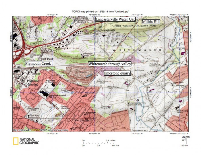
Figure 12: Whitemarsh Valley just north of the metamorphic and igneous rock ridge through which the Wissahickon Gorge is cut. Wissahickon Creek flows in a south direction near the east edge of the map across the Whitemarsh Valley to reach the gorge entrance seen in figure 14. Plymouth Creek drains in a south and southwest direction to eventually reach the Schuylkill River (upstream from the Schuylkill River gorge). The Whitemarsh through valley near the map center links the Wissahickon Creek valley with the Plymouth Creek valley and has an elevation of 206 feet where the railroad crosses the drainage divide (just north of the limestone quarry). The entire Whitemarsh Valley area is lower in elevation than crest elevations on the metamorphic and igneous rock ridge through which the downstream Wissahickon Creek gorge is cut. United States Geological Survey map presented using National Geographic TOPO software.
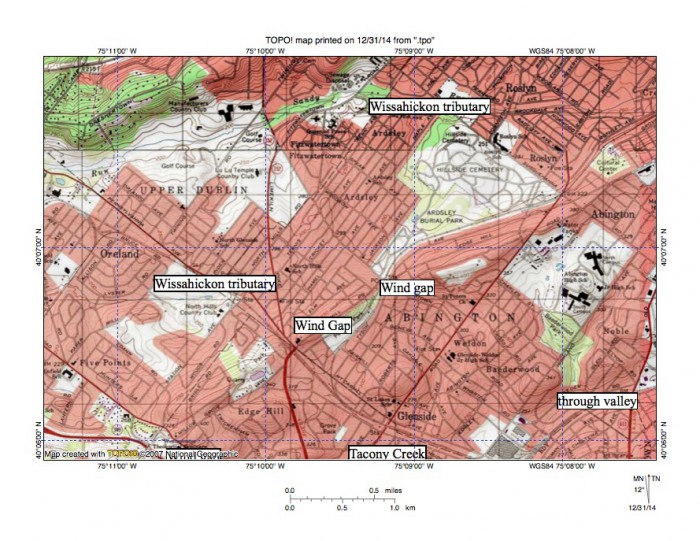
Figure 13: Sandy Run-Tacony Creek drainage divide. Camp Hill is the ridge in the map northwest corner and Sandy Run flows in a southwest direction just south of Camp Hill. Edge Hill is a ridge extending in a northeast direction from the the map south edge (near southwest corner) and is notched by marked wind gaps. East oriented Tacony Creek headwaters are south of the Edge Hill ridge and meet a southwest oriented through valley (linked to a northeast oriented Pennypack Creek tributary) at approximately the location of the large industrial plant near the map south edge. Where the east oriented Tacony Creek valley joins the southwest oriented through valley Tacony Creek turns to flow in a south direction to reach the Delaware River. The Edge Hill ridge was formed as southwest oriented flow eroded less resistant bedrock both to the northwest and the southeast. Wind gaps mark locations of flow channels that crossed the emerging ridge. Headward erosion of the south oriented Tacony Creek valley captured southwest oriented flow that had been moving to the actively eroding Wissahickon Creek valley (although that flow had been moving at elevation equivalent to the Edge Hill ridge crest elevation today).
Wissahickon Creek flows at an elevation of about 120 feet where it enters the Wissahickon Gorge near Chestnut Hill College and of about 30 feet where it leaves the gorge to join the Schuylkill River. Wissahickon Creek flows in a south-southeast direction through the gorge’s northern six miles and then turns to flow in a southwest direction for the final mile to reach the southeast oriented Schuylkill River. The gorge is approximately 300 feet deep for most of its length and has been eroded across erosion resistant rock, which is in places exposed in outcrops along the valley walls, on the Wissahickon Creek channel floor, and in valleys of tributary streams flowing into the gorge. Tributary valleys draining into the gorge almost always originate on the high ridge crest. Tributaries from the east are almost always oriented in a southwest direction while some, but not all tributaries from west are oriented in northeast directions and join Wissahickon as barbed tributaries. Tributaries to the southeast oriented Schuylkill River gorge, which was cut through the same erosion resistant metamorphic and igneous rock ridge, also show a pronounced northeast to southwest orientation and many join the Schuylkill River as barbed tributaries.

Figure 14: North entrance to the Wissahickon Creek gorge at the Philadelphia city line. The city line is marked and extends in a northeast direction from near map southwest corner to just east of the map north center edge. Wissahickon Creek is flowing at an elevation of approximately 120 feet where it enters the gorge. Elevations greater than 400 feet can be found on either side of gorge meaning the gorge is approximately 300 feet deep. The marked Andorra Wind Gap links the valleys of a northeast oriented Wissahickon Creek tributary and a southwest oriented Schuylkill River tributary and has an elevation of 266 feet. United States Geological Survey map presented using National Geographic TOPO software.
Wissahickon Gorge (water gap) in Philadelphia Fairmont Park: discussion
Perhaps the most important question that needs to be answered is how was Wissahickon Creek, which today has a relatively small drainage basin, able to erode a seven-mile long gorge in erosion resistant rock when lower routes exist to the east and much lower routes exist to the west and southwest? To answer this question we need to recognize that Wissahickon Creek drainage basin erosion began with the Wissahickon Gorge because it is eroded across some of the highest elevations and into some of the most erosion resistant bedrock found in the Wissahickon Creek drainage basin. As seen in figure 14 elevations on either side of the gorge north entrance exceed 400 feet, which is higher than many elevations along drainage divides separating the Wissahickon Creek drainage basin from drainage basins further to the west and also higher than some elevations along the Wissahickon Creek-Tacony Creek drainage divide to the east. The high elevations surrounding the Wissahickon Gorge entrance mean gorge erosion occurred when elevations in the present day Wissahickon Creek drainage basin further to the north must have been even higher than elevations surrounding the gorge entrance today. Southwest and northeast oriented tributaries flowing to both Wissahickon Creek and the Schuylkill River (figure 11) provide evidence that when the Wissahickon and Schuylkill gorges were eroded large volumes water were moving in multiple southwest oriented channels across the upland now bounding both the Wissahickon Gorge and the Schuylkill Gorge. Schuylkill River valley headward erosion first captured the southwest flow with water on northeast ends of the beheaded channels reversing flow direction to create northeast oriented tributaries. Since some northeast oriented tributary valleys are not trivial the reversed flow in them may have been able to capture flow from channels north and west of the eroding Schuylkill River valley head, which suggests the Schuylkill River valley and the Wissahickon Creek valley were being eroded headward across large (and probably prolonged) southwest oriented floods. If so, the Schuylkill River gorge erosion occurred slightly in advance of Wissahickon Creek gorge headward erosion, which beheaded southwest oriented flow channels moving water to what is now the Schuylkill River gorge. Schuylkill River gorge headward erosion apparently proceeded fast enough to progressively capture new sources of southwest oriented flow much more rapidly than Wissahickon Creek valley headward erosion could behead the southwest oriented flow channels.
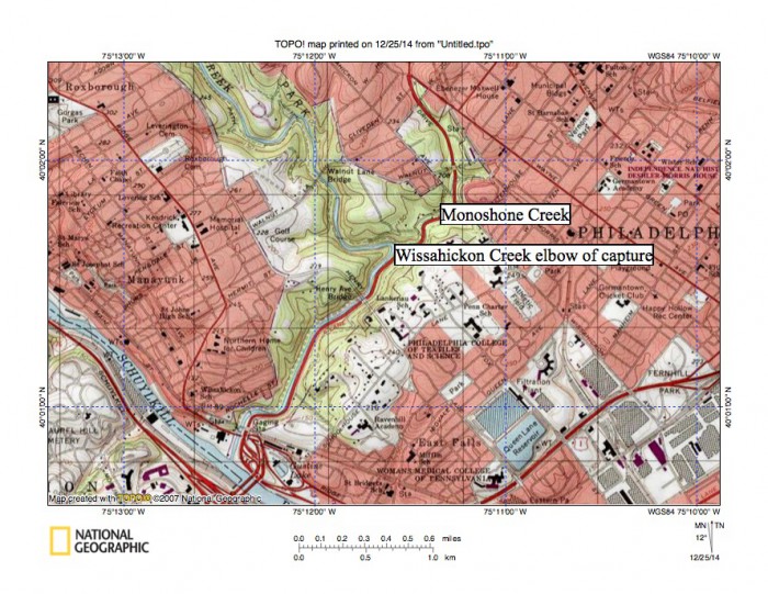
Figure 15: Wissahickon Creek elbow of capture at Monoshone Creek and the Wissahickon Creek confluence with the Schuylkill River. United States Geological Survey map presented using National Geographic TOPO software.
Additional Comments and Interpretations
Wind gaps and other evidence seen along the Wissahickon-Tacony Creek drainage divide (figure 13) suggest the southwest oriented Delaware River segment in northeast Philadelphia (and upstream) was being eroded by the same immense floods that were eroding the Schuylkill River valley and the Wissahickon Creek drainage oriented valleys were also being eroded headward from the actively eroding Delaware River valley. These south-oriented Delaware River tributary valleys were eroded in sequence from the west to the east as Delaware River valley headward erosion progressed. Tacony Creek valley headward erosion was initiated prior to Pennypack Creek valley headward erosion, which was initiated prior to Neshaminy Creek valley headward erosion, which occurred prior to headward erosion of the southeast and south oriented Delaware River valley segments in the Trenton, New Jersey area (and upstream). The valley erosion sequence described here explains numerous barbed tributaries, elbows of capture, and through valleys that now cross the drainage divides.
To briefly describe the Delaware River tributary valley sequence Tacony Creek valley headward erosion captured southwest oriented flow moving across the present day Pennypack Creek drainage basin and also began to capture south oriented flow from the present day Wissahickon Creek drainage basin. However, when headward erosion of the deep Wissahickon Creek valley broke through the metamorphic and igneous rock complex to create the Wissahickon Gorge and began to erode headward into the much easier to erode Whitemarsh Valley carbonate rock units all south oriented flow to the Tacony Creek drainage basin ended and the present day Wissahickon Creek-Tacony Creek drainage divide was created. Pennypack Creek valley headward erosion subsequently beheaded southwest oriented flow moving along the present day Meadow Brook valley to the newly eroded Tacony Creek drainage basin (and created the Tacony Creek drainage basin as we see it today) and also beheaded southwest oriented flow channels that had been supplying water to what at that time was the newly eroded Wissahickon Creek drainage basin in the Whitemarsh Valley and Fort Washington areas. Headward erosion of the south oriented Neshaminy Creek valley next beheaded all southwest oriented flow to the newly eroded Pennypack Creek drainage basin (and created the Pennypack Creek drainage basin as we see it today) and subsequently captured and beheaded (and in some cases reversed flow on northeast ends of) southwest oriented flow channels to the newly eroded Wissahickon Creek drainage basin (and created the Wissahickon Creek drainage basin as we see it today). Delaware River valley headward erosion east of the Neshaminy Creek drainage basin subsequently captured and beheaded all southwest oriented flow routes to the newly eroded Neshaminy Creek drainage basin (and created the Neshaminy Creek drainage basin as we see it today).
A similar, but somewhat different progressive sequence of south oriented Schuylkill River tributary valleys occurred as the southeast oriented Schuylkill River valley eroded headward. While Wissahickon Creek valley headward erosion should have captured the southwest oriented flow before south oriented valleys further to the west could erode headward that did not happen. Instead the difficulty in eroding the deep Wissahickon Gorge through the northwest Philadelphia metamorphic and igneous rock complex delayed Wissahickon Creek valley headward erosion long enough to permit headward erosion of the south oriented Skippack-Perkiomen Creek, Stony Creek, and Plymouth Creek valleys to the west, with the westernmost Skippack-Perkiomen valley being able to erode headward the fastest. The Wissahickon Creek valley when it finally broke through the metamorphic and igneous rock barrier was able to capture and behead southwest oriented flow routes to what at that time were the already actively eroding Plymouth Creek and Stony Creek valleys (and in the process created the Plymouth Creek and Stony Creek drainage basins we see today) and also to behead some southwest oriented flow routes to what was the actively eroding Skippack-Perkiomen Creek valley (such as the Zacharias Creek valley). But, by that time the Skippack-Perkiomen Creek valley had eroded much further to the north and was capturing southwest oriented flow from north of the Wissahickon Creek valley head. Southwest oriented flow routes to the Skippack-Perkiomen Creek valley north of what is now the Wissahickon Creek drainage basin were eventually captured and beheaded by the Neshaminy Creek valley headward erosion (which also ended flow to the Wissahickon Creek valley and which created the Wissahickon Creek drainage basin we see today) and by Delaware River valley headward erosion (which eventually captured all southwest oriented flow to the Skippack-Perkiomen Creek valley system and created the Skippack-Perkiomen drainage basin we see today). In summary the delay caused by Wissahickon Gorge erosion significantly altered the sequence of Schuylkill River tributary valley headward erosion further to the west and may be the reason the Schuylkill River valley, and not the Wissahickon Creek valley, was able to erode northward into the folded Appalachians.
The interpretation presented here requires Philadelphia area valleys to have been eroded and Philadelphia area drainage basins to have been created during what were massive and prolonged southwest oriented floods moving across the entire region. The origin of such floods cannot be determined from Philadelphia area landform evidence and it is only possible to speculate on where the water came from and on why the floods were sufficiently prolonged to erode major valley systems and to create present day drainage basins. Continental ice sheets are known to have once covered regions northeast of Philadelphia, although most interpretations of those ice sheets suggest the ice sheets occurred later in geologic history than the erosion events responsible for creating Philadelphia area valleys and drainage basins. Further most interpretations of how ice sheets melted do not suggest that massive and prolonged southwest oriented floods moved across southeast Pennsylvania. However, a large North American continental ice sheet under the right conditions could have generated massive and prolonged southwest-oriented melt water floods that could have moved across the Philadelphia region. Wissahickon Creek drainage basin evidence presented in this essay suggests the commonly held assumptions that erosion of Philadelphia area valleys and drainage basins occurred prior to the formation of continental ice sheets and that continental ice sheets did not produce massive and prolonged southwest melt water floods able to erode Philadelphia area valleys and drainage basins need to be reconsidered.

Leave a comment