
This is the second essay in which Philadelphia area drainage systems and erosional landforms as seen on detailed topographic maps are viewed as pieces of a solvable puzzle. The puzzle solution assumes running water carved the landscape features and the puzzle problem is to determine how running water accomplished that task. Each essay presents one or more detailed topographic maps in which clues to the puzzle solution are provided. Rules for solving the puzzles require all or almost all of the most obvious map evidence to be explained and that only observable evidence can be used when developing the puzzle solution. Further, the solution must be based on common sense logic without any gaps in the sequence of logic steps. In addition, the solution must address all obvious map evidence in a consistent way. Finally, if two or more solutions are found the simplest solution must be preferred.
The puzzle presented in this second essay is to determine how the drainage divide between Schuylkill River and East Branch Brandywine Creek which crosses the Chester Valley segment located between the Schuylkill River and the East Branch of Brandywine Creek was formed. Three detailed topographic maps provide the clues needed to solve this second puzzle. The first map (figure 1) shows the Schuylkill River-East Branch Brandywine Creek drainage divide crossing Chester Valley just to the east of Exton where Valley Creek East and Valley Creek West begin and flow adjacent to each other although on opposite sides of the drainage divide in a north direction down the Chester Valley south wall and once on the Chester Valley floor diverge to flow in opposite directions, with Valley Creek East flowing to the Schuylkill River and Valley Creek West to the East Branch Brandywine Creek. The map contour interval is ten feet and the east-northeast to west-southwest oriented Chester Valley which is underlain with bedrock which is less resistant to water erosion than surrounding areas is more than 200 feet deep.
Valley Creek East flows from the figure 1 map area along the Chester Valley floor in a northeast direction before reaching the figure 2 map area where Valley Creek East turns in a north direction to flow through a water gap between Mount Joy and Mount Misery (which are located along the Chester Valley’s north wall) to join a southeast-oriented Schuylkill River segment as a barbed tributary. Valley Creek West flows from the figure 1 map area on the Chester Valley floor in a southwest direction before entering the figure 3 map area where it turns in a south direction to flow through a water gap cut across the Chester Valley’s South Valley Hills before joining south-oriented East Branch Brandywine Creek just to the south of figure 3. Note in figure 1 a shallow valley on the Chester Valley floor in which water may have once flowed between northeast-oriented Valley Creek East and southwest-oriented Valley Creek West.
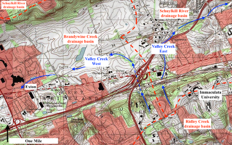
Figure 1. Modified topographic map from the United States Geological Survey (USGS) National Map website showing the northeast-southwest oriented Chester Valley segment located to the east of Exton. Red dashed lines show major drainage divides and the contour interval is 10 feet.
An analysis of the figure 1 clues might begin by asking how is it possible for two streams to begin in almost the same place and flow almost adjacent to each other into a 200-foot-deep or deeper valley and then diverge so as to flow in completely different directions to reach completely different drainage routes? Also, the analysis might ask how is it possible that a now dry shallow valley on the Chester Valley floor appears to link northeast-oriented Valley Creek East with southwest-oriented Valley Creek West? Answers to these questions might suggest that at one time the two adjacent north-oriented Valley Creeks flowed down the Chester Valley south wall to join a stream or river that was flowing in just a northeast or a southwest direction and that some event not determinable from the figure 1 evidence dismembered that stream or river so as to create the drainage divide now located between the two Valley Creeks.
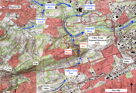
Figure 2. Modified topographic map from the USGS National Map website showing where northeast-oriented Valley Creek East turns in a north direction to leave the Chester Valley and to join the Schuylkill River as a barbed tributary. The contour interval is ten feet.
Additional clues are needed to determine how the Schuylkill River-East Branch Brandywine Creek drainage divide now crossing the Chester Valley (in figure 1) was created are seen in figure 2. Note how northeast-oriented Valley Creek East turns in a north direction to leave the Chester Valley so as to flow through a water gap between Mount Joy and Mount Misery (which are located along the Chester Valley’s north wall) and to join a southeast-oriented Schuylkill River segment as a barbed tributary. Also note that after being joined by north-oriented Valley Creek East the Schuylkill River turns from flowing in a southeast direction to flow in a northeast direction as it enters and starts to flow across the northeast-to-southwest oriented Chester Valley. Downstream from figure 2 the Schuylkill River turns to flow in a southeast direction so as to completely cross the Chester Valley and to enter the puzzle #1 map area which was illustrated in the previous essay.
The Schuylkill River enters the figure 2 map area as a southeast-oriented river but then turns in northeast and southeast direction before joining south-oriented Perkiomen Creek and then continues by making a southwest-southeast oriented loop before being joined by north-oriented Valley Creek East. Note how Pickering Creek flows in a north direction to join the Schuylkill River where the Schuylkill River makes its somewhat less obvious upstream turn from flowing in a southeast direction to flow in a northeast direction. Mount Joy and Mount Misery today are among the highest points seen in figure 2. The first questions to be answered from the figure 2 clues is what eroded the Valley Creek East water gap between Mount Joy and Mount Misery and what did the regional landscape look like at the time erosion of that water gap began?
At the time when erosion of the valley between Mount Joy and Mount Misery first began the entire region must have had an elevation equivalent to or higher than the tops of Mount Joy and Mount Misery. Starting with that now almost completely (or completely removed) landscape surface the question then becomes how did running water flowing across the region erode the northeast-to-southwest oriented Chester Valley, the Schuylkill River valley southeast-northeast-southeast oriented segment upstream from Perkiomen Creek, the Schuylkill River valley southwest and southeast oriented segment between Perkiomen Creek and Valley Creek East, the Schuylkill River valley northeast-southeast-northeast oriented segment downstream from Valley Creek East, and the Valley Creek East north-oriented valley (water gap) between Mount Joy and Mount Misery?
Water flowing in one direction or the other eroded the water gap between Mount Joy and Mount Misery. Erosion of that valley by a north-oriented stream would have been impossible if the Chester Valley had previously been eroded which suggests a south-oriented stream eroded the water gap. Supporting the south-oriented stream hypothesis is the south-oriented Schuylkill River segment immediately upstream from where Valley Creek East now joins the river and the northeast-oriented Schuylkill River immediately downstream from where Valley Creek East joins the river. What is now the Schuylkill River turn from a southeast to a northeast direction could be where two streams of south-oriented water converged so as to flow between Mount Joy and Mount Misery into an actively eroding Chester Valley. If so, the Schuylkill River did not exist in its present form at the time south-oriented water began to erode what is now the water gap between Mount Joy and Mount Misery.
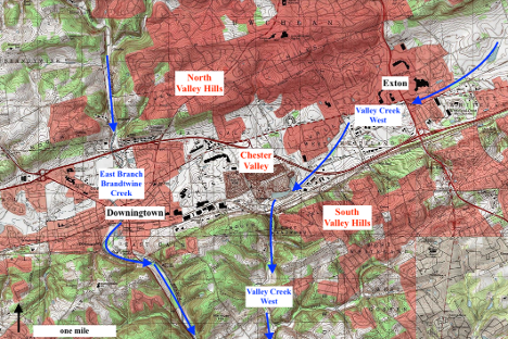
Figure 3. Modified topographic map from the USGS National Map website showing where southwest-oriented Valley Creek turns in a south direction to leave the Chester Valley before reaching the south-oriented East Branch Brandywine Creek (Valley Creek West joins the East Branch Brandywine Creek to the south of the figure). The contour interval is ten feet.
Before continuing to analyze the figure 1 and 2 map clues a final set of clues needs to be introduced. Figure 3 is located to the southwest of figure 1 and shows how the East Branch of Brandywine Creek begins to the north of the Chester Valley and flows in a south direction directly across the Chester Valley and how Valley Creek West after flowing in in a southwest direction along the Chester Valley floor towards the south-oriented East Branch Brandywine Creek turns before reaching the East Branch Brandywine Creek in a south direction to erode a water gap across the South Valley Hills. A question immediately arising from the figure 3 map evidence is why does Valley Creek West leave the Chester Valley before reaching the East Branch Brandywine Creek.
Analysis of the figure 3 evidence again needs to begin by asking what the region looked like when erosion of the Valley Creek West water gap across the South Hills first began? At that time Valley Creek West must have been flowing on a surface at least as high as the highest elevations now found in the South Valley Hills. Combining clues from figures 1, 2, and 3 it is apparent that erosion of the Valley Creek East water gap between Mount Joy and Mount Misery and erosion of the Valley Creek West water gap across the South Valley Hills was initiated by south-oriented water flowing across a surface into which the Chester Valley had yet to eroded and across which the Schuylkill River in its present form did not flow. Assuming valleys are eroded headward as shown in figure 4 the question then becomes how did running water erode each of the valleys seen in figures 1, 2, and 3 so as to create the landscape features seen today?
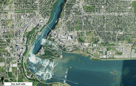
Figure 4. Imagery from the United States Geological Survey National Map website showing Niagara Falls and the downstream narrow Niagara River gorge.
Brandywine Creek and the Schuylkill River are south-oriented Delaware River tributaries which suggests all valleys seen in figures 1, 2, and 3 were eroded in a headward direction by water flowing in a south, southeast, or southwest direction. Erosion of the figure 1, 2, 3 valleys into a high-level surface that now has been mostly or completely removed probably began with headward erosion of the East Branch Brandywine Creek valley across immense volumes of southwest-oriented water. Headward erosion of the south-oriented Valley Creek West valley (to the south of its water gap) probably closely followed the East Branch Brandywine Creek valley headward erosion. At the same time West Branch Brandywine Creek valley headward erosion further to the west had cut across the less resistant Chester Valley bedrock enabling the southwest-oriented water to erode the Chester Valley headward in a northeast direction and headward erosion of the East Brandywine Creek cut across the Chester Valley alignment.
Headward erosion of the Valley Creek West valley into the developing Chester Valley next diverted at least some southwest-oriented water from the actively eroding Chester Valley in a south direction to the East Branch Brandywine Creek valley. Southwest-oriented water continued to erode the less resistant Chester Valley bedrock in a northeast direction through the figure 1 map area and then into and beyond the figure 2 map area. At least some of the southwest-oriented water flowed along what are now northeast-oriented Schuylkill River valley segments to join water that had been flowing along the south-oriented Perkiomen Creek-Schuylkill River segment which then eroded what is now the water gap between Mount Joy and Mount Misery.
Headward erosion of the now deep southeast-oriented Schuylkill River valley into and partially across less resistant Chester Valley bedrock caused a major flow reversal in what had been southwest-oriented channels leading to the water gap between Mount Joy and Mount Misery which in turn caused a reversal of flow that created what is today the northeast- and north-oriented Valley Creek East drainage route and the Schuylkill River-East Branch Brandywine Creek drainage divide that now crosses the Chester Valley (in figure 1). Further, the reversal of southwest-oriented water caused by the headward erosion of the deep southeast-oriented Schuylkill River into the less resistant Chester Valley bedrock captured Perkiomen Creek drainage and enabled the deep Schuylkill River valley to erode headward further in a northwest direction.

Leave a comment