
The divide between West Branch Red Clay Creek and the East Branch White Clay Creek near Kennett Square is crossed by at least two former west-southwest oriented water flow channels. The southern former channel east end is drained by a north, east-northeast and southeast oriented tributary to the West Branch Red Clay Creek while the west end is drained by southwest oriented Trout Run, which flows to the south oriented East Branch White Clay Creek. The northern former channel east end is drained by south and east oriented South Brook flowing to the West Branch Red Clay Creek while the west end is drained by a southwest oriented tributary to the East Branch White Clay Creek. These channels are located along bands of west-southwest oriented marble bedrock that are surrounded by more erosion resistant gneiss, schist, and quartzite. The north and east-northeast oriented segments of the stream draining the east end of the southern channel and the south and east oriented segments of South Brook draining the east end of the northern channel both flow on the channel floors almost along the Red Clay-White Clay Creek divide where they turn to the east and provide evidence that prior to headward erosion of the West Branch Red Clay Creek valley west-southwest oriented water once flowed along both channels to reach the south oriented White Clay Creek valley
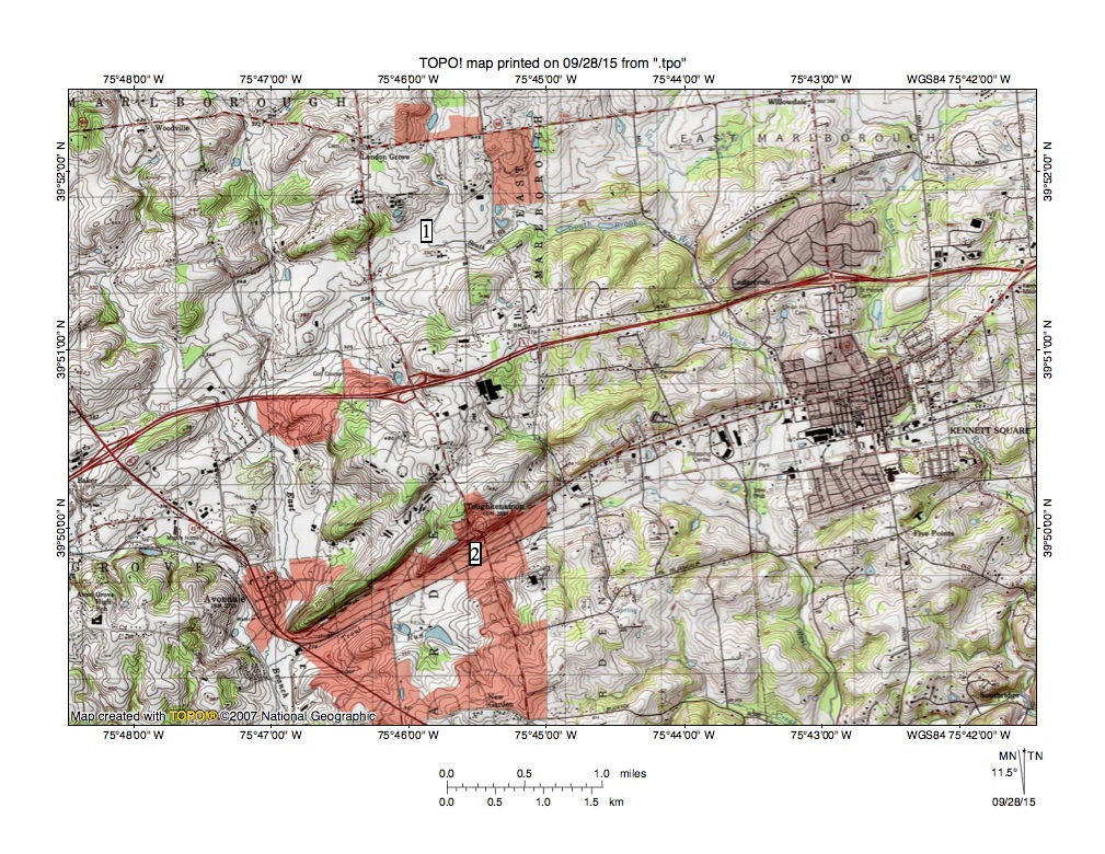
Figure 1: Map showing the divide between south-oriented West Branch Red Clay Creek (in east half of map) and south-oriented East Branch White Clay Creek (near west edge of map). Location 1 identifies the northern channel and location 2 identifies the southern channel linking the two south oriented stream valleys. See text for additional discussion. United States Geological Survey map digitally presented using National Geographic TOPO software.
Figure 1 provides a map of the West Branch Red Clay Creek-East Branch White Clay Creek divide area near Kennett Square )located near east edge of map). Location 1 identifies the northern channel linking the West Branch Red Clay Creek valley with the East Branch White Clay Creek valley. Note how South Brook flows in a south direction onto the channel floor and then turns in an east direction to reach the narrow West Branch Red Clay Creek valley. Also note how the South Brook turn on the channel floor (made precisely at location 1) is adjacent to the Red Clay Creek-White Clay Creek divide and that there is a much steeper slope to the west than along the route to the east that South Brook now uses. This asymmetrical divide provides evidence that water once flowed in a west-southwest direction along the channel floor and was beheaded and reversed by headward erosion of the deeper south oriented West Branch Red Clay Creek valley (and perhaps a segment of the South Brook valley from the West Branch Red Clay Creek valley).
Location 2 identifies the southern channel linking the West Branch Red Clay Creek valley with the East Branch White Clay Creek valley. Note how the east-northeast oriented stream draining the channel east end has north oriented headwaters and a southeast and south oriented tributary that flows through a water gap to reach the south channel floor. Also note how southwest oriented Trout Run has a tributary, which flows through a water gap to reach the channel floor and originates in a southwest oriented valley also drained by the southeast and south oriented tributary draining to the channel east end. In other words there is a third channel just north of the ridge on which the name Toughkenamon is written. Headward erosion of the southeast and south oriented valley from the southern channel beheaded southwest oriented flow in that third channel, which had been previously captured by headward erosion of the southwest oriented Trout Run tributary valley. These captures may have occurred prior to headward erosion of the deeper south oriented West Branch Red Clay Creek valley, which beheaded subsequently beheaded the southern channel and caused a reversal of flow on the southern channel east end.
These former water flow channels seen at and near the Longwood Gardens can best be explained in the context of diverging and converging flood flow channels typical of those found in flood formed anastomosing channel complexes. Evidence seen in figures 1 and 2 suggests the floodwaters were flowing in a southwest or west-southwest direction and had been captured by headward erosion of the south oriented East Branch Red Clay Creek valley. Headward erosion of the deep south-southeast oriented Brandywine Creek valley (and the southeast oriented Pocopson Creek valley segment) next beheaded the flood flow channels in sequence from south to north and in the process reversed flow on the northeast and east-northeast ends of the beheaded flood flow channels. Because the flood flow channels were beheaded in sequence from south to north reversed flood flow in a newly beheaded flood flow could capture floodwaters from flood flow channels further to the north. Such captures enabled the southern channel flow and caused a reversal of flow on the southern channel east end to create the east-northeast and southeast oriented West Branch Red Clay Creek tributary seen today.
The former west-southwest and southwest oriented water flow channels seen here can best be explained in the context of diverging and converging flood flow channels typical of those found in flood formed anastomosing channel complexes. Evidence seen in figures 1 suggests the floodwaters were flowing in a southwest or west-southwest direction and had been captured by headward erosion of the south oriented East Branch White Clay Creek valley. Headward erosion of the deep south-southeast oriented West Branch Red Clay Creek valley next beheaded the flood flow channels in sequence from south to north and in the process reversed flow on the northeast and east-northeast ends of the beheaded flood flow channels. Because the flood flow channels were beheaded in sequence from south to north reversed flood flow in a newly beheaded flood flow channel could capture floodwaters from flood flow channels further to the north. Such captures enabled the reversed flood flow to erode significant northeast and east-northeast oriented valleys. The source of the floodwaters cannot be determined from southeast Pennsylvania evidence although melt water from a large continental ice sheet would be a logical floodwater source.

Leave a comment