
Darby Creek flows in a southeast direction from near Berwyn and Daylesford, PA to southwest Philadelphia where it turns to flow in a southwest direction to join the southwest oriented Delaware River. Crum Creek headwaters are located just west of the Darby Creek headwaters near Paoli and Crum Creek flows in a south-southeast direction to join the Delaware River just downstream from where Darby Creek flows into the Delaware River. In other words, the streams originate in the same region, diverge as they flow along separate routes, but almost join before entering the southwest oriented Delaware River. This divergence and convergence is suggestive of diverging and converging channels found in an anastomosing channel complex, although this essay looks only at the Crum Creek-Darby Creek drainage divide area near Newtown Square.
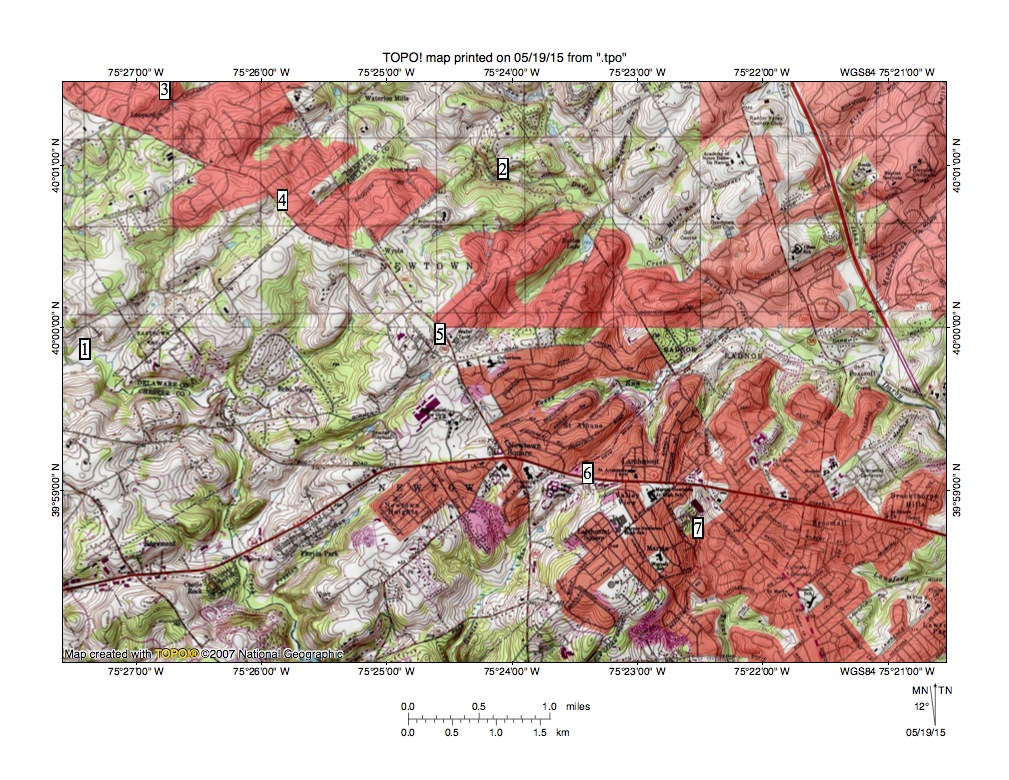
Figure 1: Crum Creek-Darby Creek drainage divide area located near Newtown Square, PA. See text below for detailed description. United States Geological Survey map digitally presented using National Geographic TOPO software.
Figure 1 illustrates the Crum Creek-Darby Creek drainage divide area located near Newtown Square. Newtown Square is the urban area located slightly south of the figure 1 center, Darby Creek is the southeast oriented stream flowing through location 2 and Crum Creek is the southeast and south-southeast oriented stream flowing through location 1. Locations 3, 4, 5, 6, and 7 identify saddles or notches found along the Crum Creek-Darby Creek drainage divide. Note how each of those saddles or notches links the valley of a northeast oriented tributary flowing to southeast oriented Darby Creek with the valley of a southwest oriented tributary flowing to southeast and south-southeast oriented Crum Creek. The northeast oriented Darby Creek tributaries can be classified as barbed tributaries in that they flow in a north direction to join a south oriented stream. Also note how Darby Creek tributaries from the northeast flow in southwest directions.
The geologic map found at the Pennsylvania Geological Survey website shows the entire Crum Creek-Darby Creek drainage divide area near Newtown Square to be in the Piedmont Province and to be underlain by metamorphic rocks, primarily gneiss. While there is a southwest to northeast orientation of some metamorphic rock units the map contains no evidence suggesting that the northeast and southwest alignment of the Darby and Crum Creek tributaries is related to geologic structures, such as beds of alternating erosion resistance, or to zones of weakness, such as fault lines.
Instead the northeast and southwest oriented tributaries and the saddles or notches crossing the drainage divide suggest closely spaced southwest oriented flow flood flow channels (such as might be found in an anastomosing channel complex) crossed the region as the deeper Crum and Darby Creek valleys eroded headward into the region. Headward erosion of the southeast and south-southeast oriented Crum Creek valley captured southwest oriented flood flow first with floodwaters on northeast ends of beheaded flood flow channels reversing flow direction to flow in northeast directions to the deeper Crum Creek valley. Because the flood flow channels were anastomosing (converging and diverging) and were not deep the reversed flow channels captured yet to be beheaded floodwaters located further to the northwest. Such captured floodwaters helped erode northeast oriented Crum Creek tributary valleys (not seen in figure 1).
The process would have been repeated as the deep Darby Creek valley eroded headward across the southwest oriented flood flow channels supplying water to the actively eroding southwest oriented Crum Creek tributary valleys. Floodwaters on northeast ends of the beheaded southwest oriented flood flow channels reversed flow direction to flow in northeast directions to the newly eroded and deeper south-southeast oriented Crum Creek valley and captured yet to be beheaded floodwaters moving north of the actively eroding Darby Creek valley head. For example, when headward erosion of the Darby Creek valley head captured southwest oriented flood flow across location 6 floodwaters were still flowing in southwest directions across location 5 and could be captured by the reversed flow now moving in a northeast direction to enter the newly eroded and much deeper southeast oriented Darby Creek valley. Erosion of the Crum Creek and Darby Creek valleys would only have been possible if massive and prolonged southwest oriented floods were moving across the region. The source of the floodwaters cannot be determined from southeast Pennsylvania evidence, although melting of a large continental ice sheet could probably generate the volumes of water required.

Leave a comment