
Ridley Creek flows in a south-southeast direction along the west edge of Media and eventually reaches the southwest oriented Delaware River while Chester Creek flows in a southeast direction approximately 3 kilometers to the west and independently reaches the Delaware River. In addition to being two closely spaced and roughly parallel southeast oriented Delaware River tributaries Ridley Creek are both joined by northeast oriented and barbed tributaries from the southwest and by southwest oriented tributaries from the northeast. Shallow through valleys link headwaters of northeast oriented Ridley Creek tributaries with headwaters of southwest oriented Chester Creek tributaries.
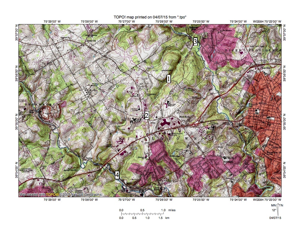
Figure 1: Ridley Creek-Chester Creek drainage divide area located west of Media, PA. See text below for detailed description. United States Geological Survey map digitally presented using National Geographic TOPO software.
Figure 1 illustrates the Ridley Creek-Chester Creek drainage divide area located west of Media. Media is the urban area located along the figure 1 east edge, Ridley Creek is the south-southeast stream flowing through location 3 and Chester Creek is the southeast oriented stream flowing through location 4. Dismal Run at location 1 is a northeast oriented barbed tributary flowing from the Ridley Creek-Chester Creek drainage divide at location 2 to join south-southeast oriented Ridley Creek as a barbed tributary at location 3. A shallow through valley at location 2 links the northeast oriented Dismal Run valley with a southwest, northwest, and southwest oriented Chester Creek tributary valley, which is linked by a shallow through (south of location 2) with the valley of the southwest oriented tributary joining Chester Creek at location 4.
The geologic map found at the Pennsylvania Geological Survey website shows a southwest to northeast oriented contact between metamorphic rock units located along the present day route of northeast oriented Dismal Run and the straightness of the Dismal Run valley suggests the contact may be a fault line. However the straight valley does not continue to the southwest of location 2 suggesting the contact/fault line did not play a major role in shaping the regional drainage pattern. Likewise, the regional metamorphic rock structures have a southwest to northeast orientation, but there is enough variance in the drainage pattern to suggest the underlying geology played at most only a partial role in shaping the pre Ridley and Chester Creek drainage pattern.
Probably the northeast and southwest oriented tributaries and the shallow through valleys crossing the drainage divide suggest closely spaced southwest oriented flow flood flow channels (such as might be found in an anastomosing channel complex) crossed the region as the Ridley and Chester Creek valleys eroded headward into the region. Headward erosion of the southeast oriented Chester Creek valley captured the southwest oriented flood flow first with floodwaters on northeast ends of beheaded flood flow channels reversing flow direction to flow in northeast directions to the much deeper Chester Creek valley. Because the flood flow channels were anastomosing (converging and diverging) and were not deep the reversed flow channels were able to capture yet to be beheaded floodwaters located further to the northwest. Such captured floodwaters helped erode the northeast oriented Chester Creek tributary valleys seen today.
The process would have been repeated as the deep Ridley Creek valley eroded headward across the southwest oriented flood flow channels supplying water to the actively eroding southwest oriented Chester Creek tributary valleys. Floodwaters on northeast ends of the beheaded southwest oriented flood flow channels reversed flow direction to flow in northeast directions to the newly eroded and deeper south-southeast oriented Ridley Creek valley and captured yet to be beheaded floodwaters moving north of the actively eroding Ridley Creek valley head. Dismal Run tributaries illustrate how such a capture occurred. Note the northeast and east oriented Dismal Run tributary north of location 1 is linked by a shallow through valley with the south oriented (and barbed) Dismal Run tributary north of location 2. Southwest oriented flood flow moving the newly reversed Dismal Run flood flow channel eroded the south oriented tributary valley and also helped erode the deep northeast oriented Dismal Run valley. Headward erosion of the deep east oriented Dismal Run tributary valley segment then beheaded a reversed the southwest oriented flood flow channel to create the northeast oriented tributary valley segment.

Leave a comment