
The towns of Villanova, Rosemont, and Bryn Mawr are located Schuylkill River-Delaware River drainage divide with Rosemont being located on the divide between Mill Creek, which flows to the Schuylkill River, and Meadowbrook Run, which flows to Darby Creek, which then flows to the Delaware River. The drainage divide elevation at the Rosemont saddle location is between 360 and 370 feet while the drainage divide rises to more than 430 feet in Bryn Mawr (to the southeast) and to more than 430 feet (just to the northwest). This saddle is evidence of a former water flow route across what is today the drainage divide between two major and different river drainage basins.
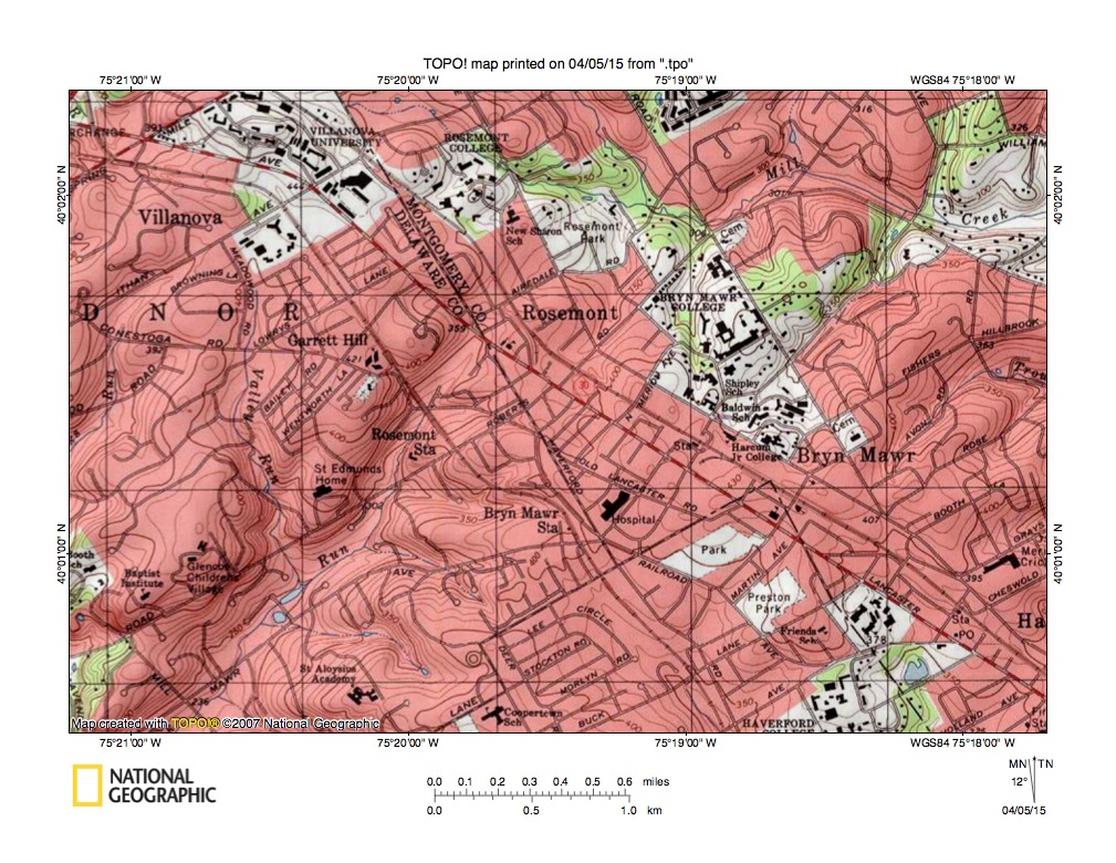
Figure 1: Map of the Rosemont saddle area. United States Geological Survey map digitally presented using National Geographic TOPO software.
Figure 1 illustrates the Rosemont saddle area with the saddle being located near the county line just west of the word “Rosemont”. Meadow Run flows in a southwest direction from the saddle and south and west of figure 1 joins southeast, south, and southeast oriented Darby Creek, which eventually reaches the Delaware River. Mill Creek flows in an east direction from near Villanova University to the figure 1 east edge and east of figure 1 turns in a south-southeast and then northeast direction to reach the Schuylkill River. The evidence suggests headward erosion of the east oriented Mill Creek valley beheaded a southwest oriented channel supplying water that eroded of the Meadow Run valley. While not obvious in figure 1 a southwest oriented Mill Creek tributary is located along the same alignment as the southwest oriented Meadow Run valley.
Looking just at the figure 1 the Rosemont saddle area evidence could be considered to be a case of simple stream capture where headward erosion of the Mill Creek valley has beheaded the Meadow Run valley and captured the Meadow Run headwaters. But the Rosemont saddle is not the only saddle found along the Schuylkill River-Delaware River drainage divide. North and west of figure 1 another shallow saddle located near Radnor today is a major transportation route used by the SEPTA Norristown High Speed Line and an Interstate Highway (route 476). Looking at figure 1 note how Valley Run originates in a shallow saddle on the Villanova University campus and drains in a south direction to join Meadow Run. These and other saddles suggest multiple flow channels crossed the present day Schuylkill River-Delaware River drainage divide and are better explained by a southwest oriented anastomosing channel complex that was first captured by headward erosion of the deep Darby Creek valley and its tributary valleys and subsequently captured by headward erosion of the deeper Schuylkill River valley and its tributary valleys. Saddles, such as the Rosemont saddle, notched into the Schuylkill River-Delaware River drainage divide provide evidence of massive and prolonged southwest oriented floods that once flowed across what are today the Main Line suburbs.

Leave a comment