
A well defined northeast-to-southwest oriented through valley links the northwest oriented Deer Run valley with the southwest oriented East Branch Perkiomen Creek valley. The Deer Run valley drains to southeast, east, and south oriented Tohickon Creek, which flows to the southeast oriented Delaware River and the East Branch Perkiomen Creek drains to south and southwest oriented Perkiomen Creek, which flows to the southeast oriented Schuylkill River. The through valley is therefore crossing the Delaware-Schuylkill River drainage divide and the present day through valley provides evidence that water once crossed the divide between these two major river basins.
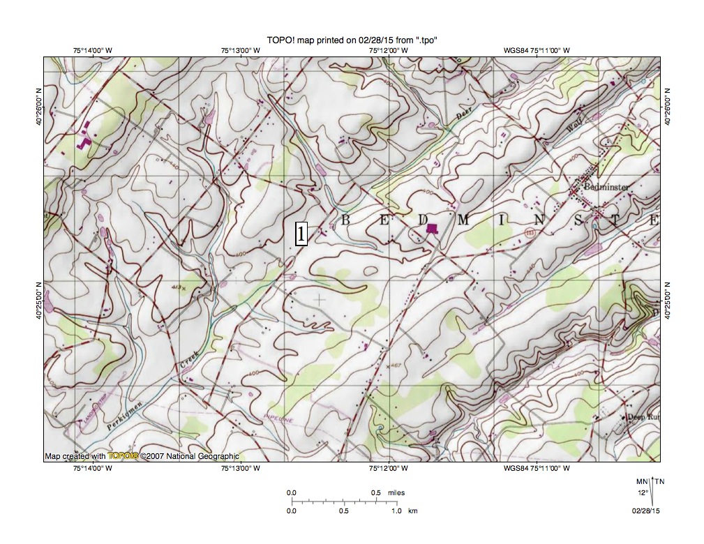
Figure 1: The through valley linking southwest oriented East Branch Perkiomen Creek with northeast oriented Deer Run at location number 1 crosses the drainage divide between the Delaware River and the Schuylkill River. United States Geological Survey map digitally presented using National Geographic TOPO software.
Figure 1 illustrates the through valley and surrounding region with the number 1 located in the through valley. Deer Run drains the through valley northeast end in a northeast direction to the figure 1 north edge. North and east of figure 1 Deer Run joins southeast, east, and south oriented Tohickon Creek, which then flows to the southeast-oriented Delaware River. East Branch Perkiomen Creek drains the through valley southwest end in a southwest direction to the figure 1 south edge. South and west of figure 1 East Branch Perkiomen Creek joins south and southwest oriented Perkiomen Creek, which flows to the southeast oriented Schuylkill River. Northeast oriented drainage routes draining to the figure 1 east edge are Tohickon Creek tributaries and the stream in the figure 1 northwest corner is also a Tohickon Creek tributary.
The northeast-to-southwest oriented ridge and valley pattern seen in figure 1 is related to the underlying geology. The Pennsylvania Geologic Survey web applications map shows the bedrock under the major ridges to be argillite of the Triassic Lockatong Formation while bedrock underlying the surrounding regions is shale, mudstone, and siltstone of the Triassic Brunswick Formation. The linear ridges suggest the underlying bedrock units have been tilted and that the Lockatong Formation argillite is more erosion resistant than the Brunswick Formation shale, mudstone, and siltstone. While bedrock composition and structure explains why valleys and ridges developed where the valleys and ridges now exist the bedrock composition and structure does not explain how, why, and when water flowed across what is today the drainage divide between two major river drainage basins.
To understand how the through valley was eroded it is necessary to reconstruct the regional topography to the way it looked prior to erosion of the through valley. At that time there was no deep southeast oriented Delaware River valley located east of figure 1 and the entire region was at as high, or higher, than the highest points in figure 1 today (also at that time sea level probably was significantly lower than it is today so the term elevation is used here in reference to points in figure 1, not in reference to sea level). What the higher-level topographic surface looked like is impossible to determine, although massive and prolonged southwest oriented floods moved across the region. Regional geologic structures may have helped determine the southwest flood flow direction, although floodwaters were also flowing to deep valleys that were eroding headward from the coastline to capture the immense southwest oriented flood flow.
Southwest oriented flood flow moving across the figure 1 map area once flowed to the actively eroding southeast-oriented Susquehanna River valley and the southwest oriented Pequea Creek and Conestoga River valleys, which eroded headward along southwest oriented flood flow channels from that newly eroded Susquehanna River valley. Next headward erosion of the south and southeast oriented Brandywine Creek valley and its tributary valleys from the actively eroding and deep southwest-oriented Delaware River valley (at Wilmington, Delaware) captured at least some of the southwest oriented flood flow (in the Honey Brook region between Welsh Mountain and the Baron Hills). Headward erosion of the southeast oriented Schuylkill River valley (from the actively eroding southwest oriented Delaware River valley at Philadelphia) beheaded (and reversed) the southwest oriented flood flow channels to the newly eroded Pequea Creek, Conestoga River, and Brandywine Creek valleys and diverted the floodwaters to the newly eroded southwest oriented Delaware River valley at Philadelphia.
The deep south- and southwest-oriented Perkiomen Creek-East Branch Perkiomen Creek valley eroded headward from the deep Schuylkill River valley across and along southwest oriented flood flow channels and was responsible for eroding the through valley seen in figure 1. Headward erosion of the deep southwest-oriented East Branch Perkiomen Creek valley ended when headward erosion of the much deeper south-oriented Delaware River valley and its deep southeast- and east-oriented Tohickon Creek valley beheaded and reversed the southwest oriented flood flow channels supplying floodwaters to the actively eroding southwest-oriented East Branch Perkiomen Creek valley. The flood flow reversal occurred on the northeast end of the beheaded flood flow channel and created the northeast oriented Deer Run drainage route. Because floodwaters spilled from one flood flow channel to another the deeper reversed flood flow channel captured floodwaters from adjacent flood flow channels. Southeast and northeast oriented Deer Run tributary valleys were eroded by floodwaters from adjacent flood flow channels that flowed to the newly reversed northeast oriented Deer Run drainage route.

Leave a comment