
Shallow wind gaps in Souderton and Telford area link headwaters of northeast and southwest oriented Perkiomen Creek tributaries and provide evidence of what were diverging and converging flood flow channels. Evidence of former channels include the present day southwest oriented East Branch Perkiomen Creek valley, a shallow wind gap in Telford linking a northeast oriented Mill Creek tributary (note how Mill Creek joins the East Branch Perkiomen Creek as a barbed tributary) and southwest oriented Indian Creek (which joins the East Branch Perkiomen Creek), and a shallow wind gap in Souderton linking the Mill Creek valley with southwest oriented Skippack Creek headwaters (with Skippack Creek eventually joining Perkiomen Creek). In addition what might be considered a hogback ridge is located just south of the Perkiomen Creek valley and the linear northeast-to-southwest oriented through valley located along the southeast side of that ridge provides evidence of still another channel.
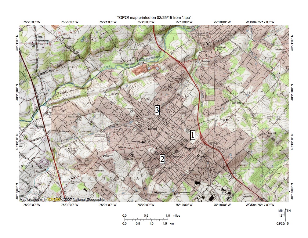
Figure 1: Evidence of diverging and converging channels in the Souderton-Telford region. See text for detailed description. United States Geological Survey map digitally presented using National Geographic TOPO software.
Figure 1 illustrates the Souderton-Telford region with East Branch Perkiomen Creek flowing in a southwest direction across the map northwest quadrant. Mill Creek originates near location 1 and flows in a northeast and north direction to join southwest oriented East Branch Perkiomen Creek as a barbed tributary near the figure 1 north edge. Skippack Creek originates near location 2 and flows in a southwest and south direction to eventually join south and southwest oriented Perkiomen Creek, which then joins a southwest oriented segment of southeast oriented Schuylkill River. Location 3 identifies headwaters of a northeast oriented Mill Creek tributary and the shallow wind gap linking that northeast oriented tributary valley with the southwest oriented Indian Creek valley, which west of figure 1 drains to southwest oriented East Branch Perkioment Creek.
Also of interest are southwest and south oriented streams located in the figure 1 southeast corner. Those streams are headwaters of the West Branch Neshaminy Creek, which south of figure 1 turns to flow in a northeast and east direction before joining southwest oriented North Branch Neshaminy Creek to form southeast and south oriented Neshaminy Creek, which flows to the southwest oriented Delaware River. In other words the Schuylkill River-Delaware River drainage divide crosses the figure 1 southeast corner in a southwest-to-northeast direction and is roughly parallel to the southwest oriented East Branch Perkiomen Creek drainage route and is only about one mile removed from southwest oriented East Branch Perkiomen Creek drainage route.
The shallow wind gap between locations 1 and 2 is defined by a single 10-foot contour line (490 foot contour line) on the north side, but it links the northeast and north oriented Mill Creek valley with the southwest and south oriented Skippack Creek headwaters valley. Likewise a single 10-foot contour line (430 foot contour line) defines the shallow wind gap near location 3, but again the wind gap links the northeast oriented Mill Creek tributary valley with the southwest oriented Indian Creek valley. The northeast-to-southwest oriented linear through valley just south of East Branch Perkiomen Creek crosses the 400 foot contour line north of Telford. The relatively narrow East Branch Perkiomen Creek valley floor north of Telford has an elevation of less than 300 feet while the ridge to the north rises to more than 500 feet.
While at significantly different elevations the shallow wind gaps, the linear through valley south of the East Branch Perkiomen Creek, and the southwest oriented drainage to south and east oriented West Branch Neshaminy Creek provide evidence of what were diverging and converging southwest oriented flood flow channels prior to deep erosion that formed the present day southwest oriented East Perkiomen Creek valley and the present day south oriented West Branch Neshaminy Creek headwaters valley (seen in the figure 1 southeast corner). At the time erosion began the entire region was at least as high, if not higher, than the 500-foot plus high ridge north of the East Branch Perkiomen Creek valley (note a 565 foot Bench Mark at Tylersport in the figure 1 northeast corner). The flood flow source cannot be determined from southeast Pennsylvania evidence, although a logical source would be continental ice sheet melt water.
Headward erosion of deep valleys into the figure 1 map area occurred in a sequence determined by the headward erosion of the deep southwest oriented Delaware River valley and its southeast oriented Schuylkill River tributary valley, and of south oriented tributary valleys eroding headward from those actively eroding valleys to capture the southwest oriented flood flow. Each valley was eroding headward along and across flood flow channels and headward erosion of each deep valley beheaded the flood flow channels it captured and ended flood flow to points further to the southwest. Until captured by headward erosion of a deep valley floodwaters were flowing in shallow southwest oriented complexes of diverging and converging flood flow channels and water probably spilled easily from one channel to the next.
Until deep valleys eroded headward into a region the flood flow channels were unable to erode deep valleys, as base level was as high as the highest points in figure 1 (at least in the region). Generally the deepest flood flow channels developed along zones of easily eroded bedrock, which may be why the southwest oriented East Branch Perkiomen Creek valley was eroded deeper than the valleys on the Mill Creek-Indian Creek and the Mill Creek-Skippack Creek flood flow channels were able to erode. As the East Branch Perkiomen Creek valley was being eroded headward in a northwest direction along an easily eroded bedrock unit its deeper valley beheaded shallower diverging flood flow channels with floodwaters on the northeast ends of the beheaded flood flow channels reversing direction to flow in a northeast direction to the deeper southwest oriented flood flow channel. However, the reversed flood flow channels captured southwest oriented flood flow from still other flood flow channels (from north and east of figure 1) and by doing so were able to erode northeast and north oriented valleys seen in figure 1.
Other than the southwest oriented valleys, which eroded headward along easily eroded bedrock units, the process of eroding the figure 1 map area progressed in a southwest to northeast direction with south oriented valleys eroding headward in sequence from west to east to capture southwest oriented flood flow near the figure 1 south edge while north and northeast oriented valleys eroded headward from the actively eroding East Branch Perkiomen Creek valley to capture southwest oriented flood flow moving on the upland surface between the actively eroding East Branch Perkiomen Creek valley and the developing south-facing escarpment near the figure 1 south edge.

Leave a comment