
Christiana is a small community located about 50 miles west of Philadelphia and just north of a water gap where East Branch Octoraro Creek headwaters cross the North Valley Hills. South of that water gap the East Branch Octoraro Creek flows across the east-northeast oriented Chester Valley and then flows through another water gap as it enters a narrow valley carved in the South Valley Hills and flows in a south-southwest direction to join Octoraro Creek and eventually reach the Susquehanna River. Valley Creek is a west-southwest oriented tributary in the Chester Valley and Valley Creek tributaries from the north and south have eroded water gaps across the North and South Valley Hills respectively. North of Christiana East Branch Octoraro Creek headwaters are located just south of a wind gap at Gap, located between Mine Ridge and Gap Hill.
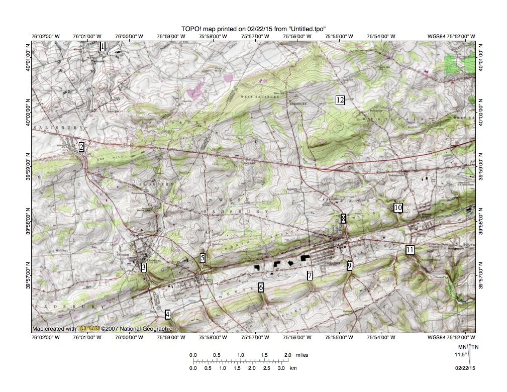
Figure 1: Water and wind gaps in the Christiana area. See text for detailed description. United States Geological Survey map digitally presented using National Geographic software.
Figure 1 illustrates the East Branch Octoraro Creek headwaters region north of Christiana. Location 1 shows west and southwest oriented Pequea Creek, which originates between Welsh Mountain and the Baron Hills and which flows to the Susquehanna River. Location 2 identifies the wind gap and town of Gap north of East Branch Octoraro Creek headwaters. Location 3 marks the water gap at Christiana where East Branch Octoraro Creek crosses the North Valley Hills to enter the Chester Valley and location 4 is where East Branch Octoraro Creek enters its second water gap to cross the South Valley Hills. Locations 5, 6,and 7 identify water gaps used by tributaries to west-southwest oriented Valley Creek, which joins East Branch Octoraro Creek in the Chester Valley. Locations 8 and 9 mark water gaps used by tributaries to an east-northeast oriented Chester Valley stream that joins southeast oriented Buck Run in the Chester Valley between locations 10 and 11. Location 12 marks a wind gap between Buck Run and headwaters of a northeast-oriented West Branch Brandywine Creek tributary. Buck Run is a West Branch Brandywine Creek tributary with water eventually reaching the Delaware River. The Delaware River-Susquehanna River drainage divide crosses the Chester Valley at Parkesburg (the town north of locations 7 and 9).
Evidence in figure 1 is significant because it not only illustrates multiple water and wind gaps it also illustrates how streams and the major drainage divide between the Delaware River and Susquehanna River ignore the present day Chester Valley and cross it just as though the well-defined Chester Valley did not exist. Further streams flowing through many, if not all of the water gaps, do not have drainage basins large enough to erode their valleys across the North and South Valley Hills. And, why does Pequea Creek in the northwest quadrant of figure 1 flow in a west and southwest direction to reach the Susquehanna River while just to the south drainage routes are oriented in north-to-south directions where they cross the west-southwest to east-northeast oriented Chester Valley? Running water eroded all landform features seen in figure 1 and those landform features provide an interesting puzzle as to how running water accomplished that task.
To fully understand evidence in figure 1 it is necessary to recognize that west and south of figure 1 the Susquehanna River flows in a southeast direction before turning to flow in a southwest direction as it enters Chesapeake Bay. Also, east and south of figure 1 the Delaware River flows in a southwest direction before turning to flow in a southeast direction as it enters Delaware Bay. Prior to erosion of the Susquehanna and Delaware River valleys the entire region seen in figure 1 was at least as high if not higher than the highest points seen in figure 1, although sea level probably was much lower when the regional erosion began. At that time massive and prolonged southwest oriented floods flowed across the upland surface and were progressively captured by the headward erosion of deep valleys. The flood water source cannot be determined from southeast Pennsylvania evidence, although melt water from a large North American continental ice sheet could account for both the volumes of water required to deeply erode the region and to raise sea level sufficiently to flood the Chesapeake and Delaware Bay estuaries.
First the deep Susquehanna River valley eroded headward along a southwest oriented flood flow channel before turning to erode headward in a northwest direction across the southwest oriented flood flow channels. South, south-southwest, and southwest oriented tributary valleys then eroded headward from the actively eroding and deep Susquehanna River valley to progressively capture the floodwaters and to divert the flood flow more directly to the newly eroded and southeast-oriented Susquehanna River valley. The south and south-southwest oriented and deep Octoraro and East Branch Octoraro Creek valley eroded headward across the figure 1 map area as southwest oriented floodwaters deeply eroded regions between erosion resistant bedrock units such as the North and South Valley Hills and Gap Hill (and Mine Ridge to the west of Gap Hill).
Headward erosion of the deep East Branch Octoraro Creek valley progressed across the present day Chester Valley at a time when the Chester Valley did not exist (as a topographic valley) and continued in a north direction to erode the present day wind gap at location 2. Flow through the location 2 wind gap ended when headward erosion of the deep and west and southwest oriented Pequea Creek valley captured the flood flow north of Mine Ridge and Gap Hill and diverted the floodwaters more directly to the newly eroded Susquehanna River valley. Erosion of the deep East Branch Octoraro Creek valley across the easily eroded Chester Valley bedrock permitted southwest oriented flood flow to lower the Chester Valley floor and southwest oriented floodwaters moving on either side of the present day North and South Valley Hills began to flow into the deepening Chester Valley and in doing so eroded the water gaps seen at locations 5,6,7,8, and 9 and possibly even at locations 10 and 11 with water flowing in a southwest direction to reach the deep East Branch Octoraro Creek valley and to create the Valley Creek route.
Headward erosion of the deep southeast-oriented Delaware River valley (in the present day Delaware Bay area) was first across southwest oriented flood flow channels and closely followed headward erosion of the Susquehanna River valley. The deep Delaware River valley then turned to erode headward along a southwest oriented flood flow channel before turning (near present day Trenton, NJ) to erode headward in a north and northwest direction across the southwest oriented flood flow. As in the case of the actively eroding Susquehanna River valley deep and tributary valleys eroded headward in northwest, north-northwest, and north directions from the actively eroding and deep Delaware River valley to capture the southwest oriented flood flow.
Headward erosion of the deep Brandywine Creek valley and its Buck Run tributary valley eroded headward in a north and then northwest direction into the figure 1 map region soon after East Branch Octiraro Creek valley headward erosion had occurred. Headward erosion of the deep southeast oriented Buck Run valley from the actively eroding West Branch Brandywine Creek valley captured the southwest oriented flood flow that was moving to the newly eroded East Branch Octoraro Creek valley in the Chester Valley region and was capturing southwest oriented flood flow moving through the wind gap at location 12 when headward erosion of the West Branch Brandywine Creek valley (east of figure 1) captured the southwest oriented flood flow and ended flood flow to the newly eroded Buck Run valley and tributary valleys.
