
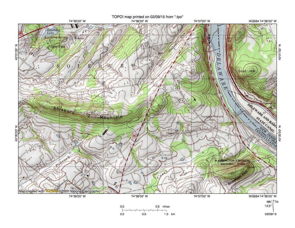
Figure 1: Solebury Mountain in Bucks County, PA. The Delaware River flows in a south and southeast direction in a water gap eroded between Solebury Mountain and Goat Hill. United States Geological Survey topographic map digitally presented using National Geographic TOPO software.
Solebury Mountain is a high ridge (more than 480 feet at its highest point while the adjacent Delaware River crosses the 40 foot contour line in figure 1) and is composed of erosion resistant bedrock while surrounding regions are underlain by less erosion resistant materials. The Pennsylvania Geological Survey web applications map shows bedrock surrounding Solebury Mountain to be composed of mudstone, shale, and siltstone of Triassic age while bedrock found at Solebury Mountain is a fine-grained igneous rock known as diabase. The diabase was intruded into the surrounding bedrock during the Mesozoic Era. All rocks exposed in the Solebury Mountain area today have been tilted and uplifted since their formation and much more recent erosion events created all of the present day landforms seen in figure 1.
Goat Hill on the east side of the Delaware River valley may an eastern extension of the Solebury Mountain intrusion. If so the Delaware River valley between Solebury Mountain and Goat Hill is a 300-foot deep water gap eroded at the time the southeast oriented Delaware River valley eroded headward across the region. Headward erosion of the Delaware River valley occurred at a time when the entire region was at least as high or higher than the present day tops of Solebury Mountain and Goat Hill. At that time massive and prolonged southwest oriented floods moved across the entire region in anastomosing complexes of shallow diverging and converging channels permitting water to move freely between flood flow channels. The southwest oriented floods were responsible for lowering the landscape surrounding Solebury Mountain and Goat Hill at the same time as the deep Delaware River valley eroded headward into the region.
Southwest oriented flood flow channels once crossed Solebury Mountain, but were unable to deeply erode the erosion resistant rock and were then channeled along the Solebury Mountain north and south flanks. Delaware River valley headward erosion reached the southern flood flow channels first and those beheaded flood flow channels reversed flow direction to flow in northeast and east directions (with some jogs to the southeast) to reach the much deeper Delaware River valley and to create what is today the Pidcock Creek drainage basin (see Pidcock Creek drainage basin entry on this website for detailed discussion). Headward erosion of the deep Delaware River valley next carved the water gap between Solebury Mountain and Goat Hill and beheaded and reversed flood flow channels north of Solebury Mountain. Reversed flow on those northern channels captured significant flood flow from north of the actively eroding Delaware River valley head and eroded the northeast-oriented valleys north of Solebury Mountain (see Aquetong Creek drainage basin entry on this website for a detailed discussion).

Leave a comment