
The Paunnacussing Creek-Pine Run Through Valley is located a short distance north and east of Doylestown and links northeast oriented Paunnacussing Creek drainage with southwest oriented Pine Run drainage. Paunnacussing Creek flows in a northeast direction to join the south oriented Delaware River as a barbed tributary. Pine Run flows in a southwest direction to join east and southeast oriented Neshaminy Creek as a barbed tributary. The through valley elevation at the drainage divide is between 380 and 400 feet. Elevations on Plumstead Hill to the northwest rise to 569 feet while elevations on the ridge to the southeast rise to 492 feet.
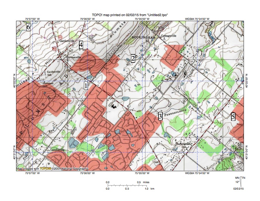
Figure 1: Paunnacussing Creek-Pine Run Through Valley. See text below for discussion. United States Geologic Survey map digitally presented using National Geographic TOPO software.
Figure 1 illustrates the Paunnacussing-Pine Run Through Valley and adjacent features. Pine Run originates at location 1 and flows in a southwest direction to the map southwest corner and south and west of figure 1 joins east and southeast oriented Neshaminy Creek as a barbed tributary. A northeast oriented Paunnacussing tributary originates at location 1 and Paunnacussing Creek originates at location 3. Paunnacussing Creek flows in a northeast direction and north and east of figure 1 joins the southeast oriented Delaware River as a barbed tributary. The drainage divide between locations 1 and 2 has an elevation of between 380 and 400 feet. The elevation at location 4 on northeast oriented Plumstead Hill is 569 feet while the elevation on the northeast oriented ridge at location 5 is 492 feet. The southeast oriented valley in the map southeast corner drains to south oriented Mill Creek, which flows to Neshaminy Creek, and suggests headward erosion of a Neshaminy Creek tributary valley almost captured the southwest oriented flood flow.
The underlying geology probably helped determine the through valley orientation although the through valley is a water eroded feature and was eroded by southwest oriented flood flow prior to headward erosion of the deep southeast- and south-oriented Delaware River valley (north and east of figure 1). At first water flowed in a southwest direction to south oriented Schuylkill tributary valleys (Skippack-Perkiomen Creek, Stony Creek, Plymouth Creek, and Wisahicickon Creek), which were eroding headward from what at that time was the newly eroded southeast oriented Schuylkill River valley. Headward erosion of the deep Neshaminy Creek valley from what at that time was the actively eroding southwest oriented Delaware River valley (to the south of figure 1) subsequently captured the southwest oriented flood flow.
North and east of figure 1 the Delaware River flows in a southeast and south direction and headward erosion of that southeast and south oriented Delaware River valley eventually captured the southwest oriented flood flow. Floodwaters on the northeast end of the beheaded flood flow channel reversed direction to flow in a northeast direction to the much deeper southeast and south oriented Delaware River valley. This reversal in flood flow created the present day northeast oriented Paunnacussing Creek drainage system. The reversed flood flow probably captured floodwaters from north of the actively eroding Delaware River valley head and such captured floodwaters helped erode the Paunnacussing Creek valley seen today

Leave a comment