
The Delaware River-North Branch Neshaminy Creek Plumstead Township through valley extends in a southwest direction from Point Pleasant along the Delaware River to southwest oriented North Branch Neshaminy Creek, which at Chalfont joins east and southeast oriented Neshaminy Creek as a barbed tributary. Geddes Creek and a tributary drain the through valley northeast end. Geddes Creek flows to the south and southeast oriented Delaware River as a barbed tributary. The Geddes Creek-North Branch Neshaminy Creek divide elevation on the through valley floor is between 400 and 420 feet. The through valley, which is more than 100 feet deep, is today used to divert water from the Delaware River to the Neshaminy Creek drainage basin.
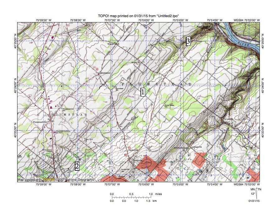
Figure 1: The Delaware River-North Branch Neshaminy Creek Plumstead Township Through Valley drainage divide is found at location 1. The North Branch Neshaminy Creek flows in a southwest direction at location 2 and Geddes Creek flows in a northeast direction at location 3 and joins the Delaware River as a barbed tributary. The map predates Bradshaw Reservoir, which now floods part of the Geddes Creek drainage basin. United State Geological Survey map digitally presented using National Geographic TOPO software.
The through valley was eroded by massive and prolonged southwest oriented flood flow prior to headward erosion of the deep south and southeast oriented Delaware River valley. Floodwaters were captured at the through valley southwest end by Neshaminy Creek valley headward erosion and diverted in an east and southeast direction to what at that time was a newly eroded southwest oriented Delaware River valley segment. Headward erosion of the deep Delaware River valley continued in a north and northwest direction to eventually capture all of the southwest oriented flood flow moving to the newly eroded Neshaminy Creek valley.
Floodwaters on the northeast end of the beheaded southwest oriented flood flow channel to what is today the North Branch Neshaminy Creek valley reversed direction to move to the newly eroded and much deeper Delaware River valley and to create the northeast oriented Geddes Creek barbed tributary seen today. Reversed flow on the newly created Geddes Creek alignment captured flood flow from yet to be beheaded flood flow channels further to the north. Such captured floodwaters helped erode the present day northeast oriented Geddes Creek valley. In the late 1980s Bradshaw Reservoir was created in the Geddes Creek drainage basin as a pumped storage area for Delaware River water being diverted to the North Branch Neshaminy Creek drainage to supplement Montgomery County and Bucks County public water supplies and to the Perkiomen Creek drainage basin to provide water for a nuclear power plant.

Leave a comment