
Newtown Creek (location 2, 4, and 5 in figure 1) is a relatively minor stream flowing in a southeast, east-northeast, and south direction near and through Newtown, PA to join southeast and south oriented Neshaminy Creek south of figure 1 (Neshaminy Creek flows in a southeast direction from location 1 to the figure 1 south edge). At least two shallow and west-southwest-to-east-northeast oriented through valleys at locations 2 and 3 cross the Neshaminy Creek-Newtown Creek drainage divide. These through valleys link southwest oriented Neshaminy Creek tributaries with the east-northeast oriented Newtown Creek segment and an east-northeast oriented Newtown Creek tributary. How did these shallow through valleys linking the south oriented Newtown Creek valley with the southeast oriented Neshaminy Creek valley form?
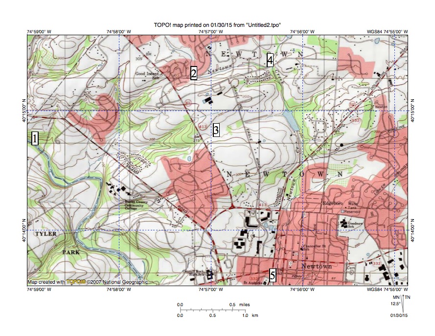
Figure 1: Neshaminy Creek flows in a southeast direction from location 1. Newtown Creek flows in a south direction to location 2 and then an east-northeast direction to location 4 and next in a south direction to location 5 and finally joins Neshaminy Creek south of figure 1. Shallow through valleys at locations 2 and 3 link the Newtown Creek valley with the Neshaminy Creek valley. Note northeast oriented stream in map southwest corner joining Neshaminy Creek as a barbed tributary. United States Geological Survey map digitally presented using National Geographic TOPO software.
The shallow through valleys were probably eroded by southwest or west-southwest oriented flood flow moving to what at that time was the newly eroded and deep southeast-oriented Neshaminy Creek valley. Floodwaters were moving across the region east of figure 1 where the south oriented Delaware River valley now exists and had been captured by headward erosion of the deep south-oriented Neshaminy Creek valley, which had eroded headward from the actively eroding southwest-oriented Delaware River valley south of figure 1. Today the Delaware River flows in a south direction east of figure 1 and then turns to flow in a southwest direction south of figure 1 and the south oriented Delaware River valley east of figure 1 had not been eroded when the deep Neshaminy Creek valley captured floodwaters in the figure 1 map region.
Events recorded by the map evidence seen in figure 1 begin with headward erosion of the deep southeast-oriented Neshaminy Creek valley across the southwest or west-southwest oriented flood flow. As the deep southeast oriented Neshaminy Creek valley eroded headward the southwest or west-southwest oriented flood flow eroded the southwest oriented tributary valleys into the newly eroded Neshaminy Creek valley northeast wall.
Next headward erosion of the shallower south-oriented Newtown Creek valley (east of the newly eroded Neshaminy Creek valley) captured the flood flow and diverted the water more directly to the newly eroded Neshaminy Creek valley (south of figure 1). Water on east-northeast ends of beheaded flood flow routes reversed flow direction to create the east-northeast oriented Newtown Creek tributary valley at location 3 and the east-northeast oriented Newtown Creek valley segment at location 2. Note west-southwest oriented Newtown Creek tributary valleys. Finally, headward erosion of the south oriented Delaware River valley east of figure 1 captured all southwest or west-southwest oriented flood flow and ended all flood movements across the figure 1 region.

Leave a comment