
The Schuylkill River flows in a south direction from Norristown to West Conshohocken where it turns to flow in an east-northeast direction to Spring Mill and then turns abruptly to flow in a southeast direction through the eight-mile long Schuylkill Gorge carved in erosion resistant metamorphic and igneous rocks. The gorge southeast end is in the City of Philadelphia. The abrupt change in flow direction at Spring Mill is here referred as the Spring Mill Elbow of Capture and is located at location 2 (seen in figure 1 below). Wissahickon Creek enters its seven-mile long gorge carved across the same erosion resistant metamorphic and igneous rock complex at location 6. The Andorra Wind Gap at location 4 links an east-northeast oriented Wissahickon Creek tributary valley with a west-southwest oriented valley draining to the Spring Mill Elbow of Capture location. The question addressed here is why does the Schuylkill River turn at Spring Mill from flowing in an east-northeast direction to flow in a southeast direction?
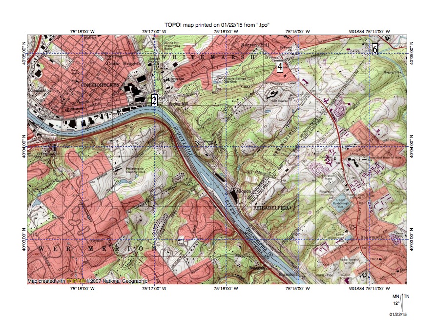
Figure 1: Spring Mill Elbow of Capture is found at location 2, the Andorra Wind Gap at location 4, and the Wissahickon Gorge north entrance at location 6. The southeast oriented Schuylkill River segment downstream from location 2 is in the Schuylkill Gorge. Note southwest oriented Schuylkill River tributaries from the northeast and northeast oriented and barbed tributaries from the southwest. United States Geological Survey map digitally presented using National Geographic TOPO software.
At the time Schuylkill River valley erosion began regional elevations were at least as high or higher than elevations surrounding the Schuylkill River valley today. In other words, the Schuylkill River valley eroded headward across a pre-Schuylkill River landscape surface that no longer exists. While little evidence remains to suggest what the pre-Schuylkill River landscape looked like there is evidence massive and prolonged southwest oriented floods moved across that landscape. The floodwaters were probably flowing in shallow diverging and converging southwest oriented channels that formed a large anastomosing channel complex. The deep Schuylkill River valley eroded headward across those southwest oriented channels (from what was probably a newly eroded and deep Delaware River valley) to capture the southwest oriented flood flow.
The southeast oriented Schuylkill River valley segment downstream from Spring Mill eroded headward across southwest oriented flood flow channels while the east-northeast oriented Schuylkill River valley segment between West Conshohocken and Spring Mill eroded along the east-northeast end of a beheaded west-southwest oriented flood flow channel. Evidence for the multiple southwest oriented flood flow channels can be seen today in the orientation of tributaries to the southeast oriented Schuylkill River segment downstream from the Spring Mill Elbow of Capture. Note how tributaries from the northeast are almost all oriented in a southwest direction while tributaries from the southwest are almost all oriented in a northeast direction and join the Schuylkill River as barbed tributaries. The northeast oriented tributary valleys were eroded by reversals of flow on the northeast ends of beheaded southwest oriented flood flow channels. Evidence for the captured west-southwest oriented flood flow channel can be seen in the opposing tributary valleys on either of the Andorra Wind Gap (location 4 in figure 1) and in the east-northeast oriented Schuylkill River valley segment upstream from Spring Mill.
The Spring Mill Elbow of Capture was formed when headward erosion of the deep southeast oriented Schuylkill River valley beheaded the west-southwest oriented flood flow channel that eroded the Andorra Wind Gap and that had formed along the west-northwest margin of the erosion resistant metamorphic and igneous rock complex through which the eight-mile long southeast oriented Schuylkill Gorge and the seven-mile long Wissahickon Gorge were carved. Water on the east-northeast end of the beheaded flood flow channel reversed flow direction to enter the much deeper and newly eroded southeast-oriented Schuylkill River valley. This reversal of flow was successful in capturing southwest oriented flow from north and west of the actively eroding Schuylkill River valley head and that captured water enabled the deep Schuylkill River valley head to erode headward in a west-southwest direction along the east-northeast oriented reversed flow channel to reach the newly eroded southeast oriented Schuylkill Gorge. In other words, the Spring Mill Elbow of Capture was formed when Schuylkill River valley headward erosion captured a west-southwest oriented flood flow channel and then eroded headward along the east-northeast end of that beheaded flood flow channel.

Leave a comment