
Wissahickon Creek flows in a southwest and south-southwest direction as it travels from its headwaters to just west of North Wales and then turns to flow in a south-southwest and south-southeast direction to pass through the first of several water gaps encountered on its journey to reach the southeast oriented Schuylkill River. South of the North Wales Water Gap Wissahickon Creek turns to flow in an east direction before turning in a south direction to flow through a second water gap at Gynedd Valley. The North Wales Water Gap is eroded across a southwest-to-northeast oriented ridge that on both sides of the water gap exceeds 450 feet in elevation, although near the water gap ridge elevations are lower. Wissahickon Creek crosses the 300-foot contour line as it flows into the water gap valley, which means Wissahickon Creek carved a 150-foot deep valley to cross the ridge.
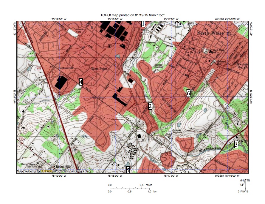
Figure 1: Wissahickon Creek turns at location 1 from flowing in a southwest direction to flow in a south-southwest and then south-southeast direction through the North Wales Water Gap at location 2 and then turns to flow in an east direction to reach the Gynedd Valley Water Gap at location 3. Location 4 shows the beheaded southwest oriented valley now drained by Zacharias Creek headwaters and location 5 shows the beheaded valley now drained by southwest oriented Stony Creek headwaters. Location 6 identifies a southwest oriented Wissahickon Creek tributary valley cut into the ridge which the North Wales Water Gap crosses.
East of Wissahickon Creek the ridge is defined its northwest flank by the southwest oriented Wissahickon Creek headwaters valley and on its southeast flank by southwest oriented Wissahickon Creek tributary valleys, one of which appears to have carved a southwest oriented valley along the ridge crest. West of Wissahickon Creek the ridge is defined on its northwest side by the southwest oriented Zacharias Creek headwaters valley and on its southeast side by the southwest oriented Stony Creek headwaters valley. Zacharias Creek flows in a southwest and west direction to join southwest and south oriented Skippack Creek, which then joins south oriented Perkiomen Creek to reach the Schuylkill River north of Valley Forge. Stony Creek flows in a southwest and south direction to join the Schuylkill River at Norristown.
The southwest oriented Wissahickon, Zacharias, and Stony Creek headwaters valleys and the southwest oriented Wissahickon Creek tributary valleys provide an example of aligned drainage and suggest that prior to headward erosion of the deep Wissahickon Creek valley the region was crossed by diverging and converging southwest oriented flow channels such as might be found in a flood formed anastomosing channel complex. If so the flood flow channels would have been formed on a surface at least as high as the highest ridge crests today and the Wissahickon Creek valley eroded headward into the region to capture the southwest oriented flood flow with the captured flood flow providing the water volumes required to erode the deep Wissahickon Creek valley.
Headward erosion of the deep Wissahickon Creek valley across what are today ridges that separate former southwest oriented flow channels would only have been possible if the flow channels were in some way interconnected or if water was spilling out of one channel in a south direction to an adjacent channel. The elbow of capture where Wissahickon Creek turns from flowing in a southwest direction to flow in south-southwest and south-southeast directions through the North Wales Water Gap before turning in an east direction to reach the Gynedd Valley Water Gap illustrates how the Wissahickon Creek valley eroded headward from one southwest oriented flow channel to the next. The east oriented Wissahickon Creek segment south of the North Wales Water Gap was initiated by a flow reversal on the northeast end of a beheaded southwest oriented flow channel, which once supplied water to what had been the actively eroding Stony Creek valley.
The North Wales Water Gap itself may have been where southwest oriented flow channels converged or diverged or it may only have been a location where water was spilling out of a flow channel on the present day southwest oriented Wissahickon Creek headwaters and southwest oriented Zacharias Creek headwaters alignment to reach the southwest oriented flood flow channel supplying water to the southwest oriented Stony Creek headwaters valley. In either case enough water was flowing between the two southwest oriented flow channels that the actively eroding Wissahickon Creek valley head was able to erode headward in a north direction to capture southwest oriented flow on the northern channel, which today serves as the southwest oriented Wissahickon Creek headwaters valley. Shortly after capturing the southwest oriented flow channel on the north side of the North Wales Water Gap headward erosion of the deep Neshaminy Creek valley (from what was probably an actively eroding southwest oriented Delaware River valley segment) beheaded all southwest oriented flow channels crossing the region and ended Wissahickon Creek valley headward erosion.

Leave a comment