
Wissahickon Creek flows through the Ambler region in a southeast direction before making a turn to flow in a southwest and then south direction through its Fort Washington Water Gap located between Militia Hill and Fort Hill. In the Amber region southeast oriented Wisahickon Creek is joined by southwest oriented tributaries from the east and by northeast-oriented barbed tributaries from the west. This northeast and southwest orientation of Wissahickon Creek tributaries is an example of aligned drainage and suggests the southeast oriented Wissahickon Creek valley eroded headward across diverging and converging southwest oriented flow channels such as might be found in a flood formed southwest oriented anastomosing channel complex.
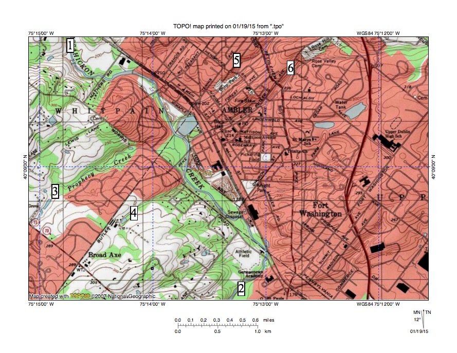
Figure 1: Wissahickon Creek in the Ambler region. See text for discussion. United States Geological Survey map digitally presented using National Geographic TOPO software.
Figure 1 shows Wissahickon Creek flowing in a southeast direction before making a southwest jog near the Germantown Academy to reach location 2. Prophecy Creek at location 4 flows in a northeast direction to join southeast oriented Wissahickon Creek as a barbed tributary and the shorter northeast oriented tributary at location also flows to Wissahickon Creek as a barbed tributary. The two southwest oriented Wissahickon Creek tributaries seen at locations 5 and 6 are on the same alignment as the two northeast oriented tributaries at locations 3 and 4.
The parallel southwest and northeast oriented valleys were initiated as parallel southwest oriented flow channels on a surface at least as high as the highest regional ridge crests today. Headward erosion of the deep Wissahickon Creek valley captured the southwest oriented flow, which then eroded the southwest oriented tributary valleys. Water on the northeast ends of the beheaded flow channels reversed flow direction to create the northeast oriented tributaries. Reversed flow on the beheaded flow channels probably captured flow from yet to be beheaded flow channels further to the north and that captured flow helped erode the northeast oriented valleys.
The parallel northeast and southwest oriented tributary valleys also help define what appear today to be southwest-to-northeast ridges that have been cut by the Wissahickon Creek valley. It is probable the tributary valleys are eroded into less erosion resistant material while the ridges are composed of more erosion resistant material and if so the locations where the Wissahickon Creek valley cuts across those ridges could be called water gaps. Some observers might question whether these are true water gaps and even if they are true water gaps they are poor examples when compared with water gaps elsewhere in Pennsylvania and even with the Wissahickon Gorge Water Gap further downstream on the Wissahickon Creek valley.

Leave a comment