
The Dresher-Pennypack Creek Through valley extends in a northeast direction from Dresher to the Pennypack Creek valley between Fulmor and Heaton and is today used by the Pennsylvania Turnpike and a Norfolk Southern freight rail line to cross the Pennypack Creek-Wissahickon Creek drainage divide. The through valley floor elevation at that drainage divide is between 290 and 300 feet. Elevations on ridges to the south and north of the through valley exceed 370 feet meaning the through valley is approximately 80 feet deep. The through valley east end is drained by a northeast and east oriented Pennypack Creek tributary while the through valley west end is drained by a southwest oriented tributary to Sandy Run, which then flows to Wissahickon Creek near Fort Washington. The through valley is a prominent water-eroded landform that serves today as a major rail and highway transportation route.
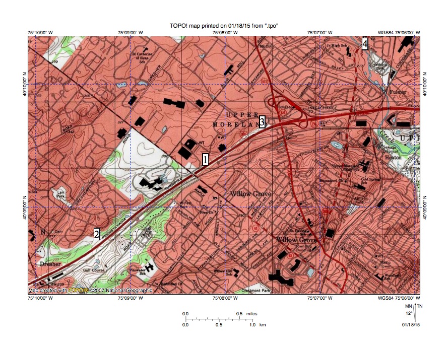
Figure 1: The Pennypack Creek-Wissahickon Creek drainage divide at location 1 crosses the Dresher-Pennypack Through Valley. A southwest oriented Wissahickon Creek tributary at location 2 drains the through valley southwest end while a northeast oriented Pennypack Creek tributary drains the through valley northeast end. Pennypack Creek flows in a south direction from location to Fulmor and Heaton before turning to flow to the map east edge. United States Geological Survey map digitally presented using National Geographic TOPO software.
The Dresher-Pennypack Creek Through Valley was eroded by southwest oriented flow prior to headward erosion of the south oriented Pennypack Creek valley now located between Fulmor and Heaton. At that time the deep south-oriented Wissahickon Creek valley had eroded into the Fort Washington area to capture southwest oriented flood flow moving across the region. The southwest oriented flood flow eroded deeper channels headward along bands of easily eroded bedrock with more erosion resistant bedrock being left as ridges between flood-flow channels.
Headward erosion of the deeper south-oriented Pennypack Creek valley from Heaton to Fulmor beheaded to the southwest oriented flow channel moving water along the Dresher-Pennypack Creek Through Valley route. Water on the northeast end of the beheaded flood flow channel reversed flow direction to create the present day northeast and east oriented Pennypack Creek tributary draining the through valley northeast end. Reversed flow probably captured southwest oriented flood moving north of the actively eroding Pennypack Creek valley head and that captured water helped erode the northeast and east oriented Pennypack Creek tributary valley.

Leave a comment