
The Marble Hall Through Valley between Spring Mill Creek and Wissahickon Creek is one of several through valleys linking the Wissahickon Creek valley upstream from the Wissahickon Gorge with the Schuylkill River valley and is located in Marble Hall between Lafayette Hill and Barren Hill. Wissahickon Creek flows in a south direction at the through valley east end and then enters its seven mile long Wissahickon Gorge carved in the erosion resistant upland before reaching the Schuylkill River. At the through valley western end Spring Mill Creek flows in a southwest and south direction through a much shorter and shallower gorge to reach the Schuylkill River. The Spring Mill Creek-Wissahickon Creek drainage divide elevation in the Marble Hall Through Valley is between 210 and 220 feet. The erosion resistant upland elevation on either side of the Wissahickon Creek Gorge exceeds 400 feet. To the north of the Marble Hall Through Valley is the slightly deeper Whitemarsh Through Valley.
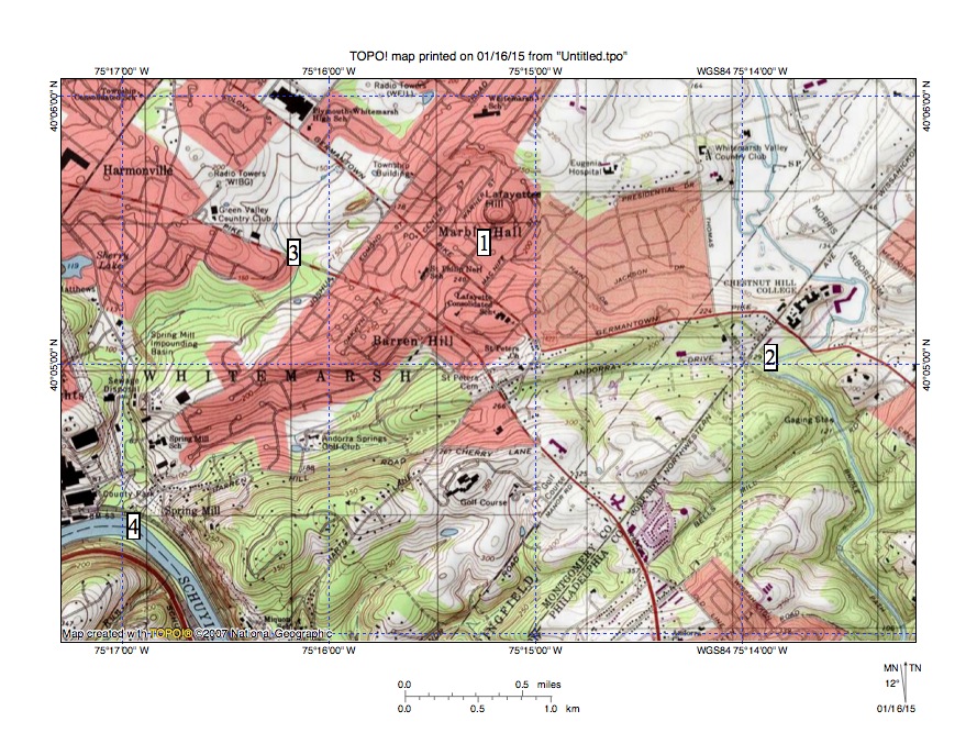
Figure 1: The Marble Hall Through Valley is found at location 1 between Lafayette Hill and Barren Hill and links south oriented Wissahickon Creek (location 2) with southwest and south oriented Spring Mill Creek (location 3). Spring Mill Creek empties into the Schuylkill River at location 4. Wissahickon Creek at location 2 is entering its seven-long gorge to reach the southeast oriented Schuylkill River south of figure 1. United States Geological Survey map digitally presented using National Geographic TOPO software.
The Marble Hall and Whitemarsh Through Valleys pose an intriguing question. Why and how did Wissahickon Creek erode a seven-mile gorge across a 400-foot high ridge of erosion resistant bedrock to reach the Schuylkill River when the Marble Hall and Whitemarsh Through Valleys provide much lower routes to reach the same Schuylkill River? Or, if the Wissahickon Gorge was eroded prior to erosion of the Marble Hall and Whitemarsh Through Valleys, then why and how were the Marble Hall and Whitemarsh Through Valleys eroded? The most logical answer to the questions is the Marble Hall and Whitemarsh Through Valleys were eroded at the same time the Wissahickon Gorge was eroded. Otherwise, if one valley had been eroded before the other valleys all water would have flowed through the first valley and erosion of the other valleys would have been impossible. Then the question becomes, under what circumstances would it be possible to erode the Marble Hall Through Valley, the Whitemarsh Through Valley and the Wissahickon Gorge at the same time?
The Marble Hall and Whitemarsh Through Valleys did not exist when regional erosion began and water flowed on a surface at least as high as the highest points surrounding the Wissahickon Gorge today (elevations of more than 420 feet are found in Chestnut Hill on the east side and near the Roxborough Filtration Plant on the west side). Massive and prolonged floods moved across the region in a southwest direction to reach what at that time was an actively eroding southeast oriented Schuylkill River valley, which was eroding its gorge headward across the same 400-foot high erosion resistant ridge the Wissahickon Gorge is carved into. The Wissahickon Gorge eroded headward into the erosion resistant ridge so as to capture southwest oriented flow moving across what is today that upland surface and eventually succeeded in eroding headward for seven miles across the erosion resistant material to reach less erosional bedrock, which underlies the Marble Hall and Whitemarsh Through Valleys.
At the same time the Schuylkill River valley was eroding its gorge across erosion resistant material faster than Wissahickon Creek valley headward erosion could capture the southwest oriented flow. As a result when the deep southeast oriented Schuylkill River valley head almost reached the north margin of erosion resistant material that the Wissahickon Creek valley was eroding its seven-mile long gorge across the Spring Mill Creek valley eroded headward and captured southwest oriented flow north of the actively eroding Wissahickon Creek valley head. Later when Schuylkill River valley headward erosion reached the erosion resistant material north margin (near Conshohocken) the Plymouth Creek valley eroded headward across easily eroded bedrock and was able to capture southwest oriented flow moving across the present day Whitemarsh Valley (although at first at an elevation of more than 420 feet) before headward erosion of the deep Wissahickon Creek valley head broke through the erosion resistant bedrock barrier and reached the less erosion resistant material.
Southwest oriented flow moving to the newly eroded southwest and south oriented Spring Mill Creek valley lowered the Marble Hall Through Valley at the same time the south oriented Wissahickon Creek valley was also eroding headward into easily eroded bedrock just east of the Marble Hall Through Valley. For a time both the Marble Hall Through Valley route to Spring Mill Creek and the Wissahickon Gorge route competed with each other to capture the southwest oriented flow. However, the Wissahickon Gorge provided a shorter route and was able to capture all southwest oriented flow moving through the present day Marble Hall Valley and then to capture large volumes of additional southwest oriented flow as it eroded still further headward (to eventually reach the present day Lansdale area). But for a short after being beheaded there was a reversal of flow in the Marble Hall Through Valley with water from southwest oriented flow routes north of the actively eroding Wissahickon Creek valley head flowing around Lafayette Hill to reach the newly eroded Wissahickon Creek valley.

Leave a comment