
Wissahickon Creek after flowing for approximately six miles in a south-southeast direction through the Wissahickon Gorge turns to flow in an east direction where it is joined by southwest oriented Monoshone Creek. But, instead of continuing in a south-southeast or east direction Wissahickon Creek makes an abrupt turn to flow in a southwest direction along the Monoshone Creek alignment for approximately one mile to reach the southeast oriented Schuylkill River. Why did a deep southwest oriented valley erode headward into erosion resistant bedrock along the present day Wissahickon-Monoshone Creek alignment? And, why did the south-southeast oriented Wissahickon Creek valley erode headward from that southwest oriented valley?
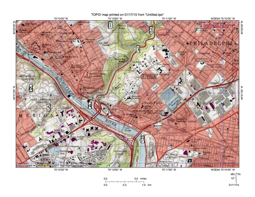
Figure 1: Wissahickon Creek flows from location 1 to locations 3 and 4. Location 2 shows Monoshone Creek. Locations 5 and 6 show northeast oriented tributaries draining to the Schuylkill River as barbed tributaries. Location 7 shows where the southeast oriented Schuylkill River begins to turn to flow in a southwest direction (see figure 2). United States Geological Survey map digitally presented using National Geographic TOPO software.
Upstream from where Wissahickon Creek joins the Schuylkill River both Wissahickon Creek and the Schuylkill River are located in gorges carved across a wide band of erosion resistant bedrock. Several through valleys just north of the erosion resistant bedrock band link the north ends of the two gorges, which suggests water once flowed in a west or west-southwest direction across the Wissahickon Creek drainage basin to reach the southeast oriented Schuylkill River (e.g. Marble Hall Through Valley and Whitemarsh Through Valley and the Andorra Wind Gap). If the southeast oriented Schuylkill Gorge and the through valleys north of the gorges already existed there would be no reason why water would erode a seven-mile long Wissahickon Gorge across the band of erosion resistant bedrock. Landform evidence in this region is like pieces of a picture puzzle. The pieces fit together in some logical way to produce an understandable picture, but how?
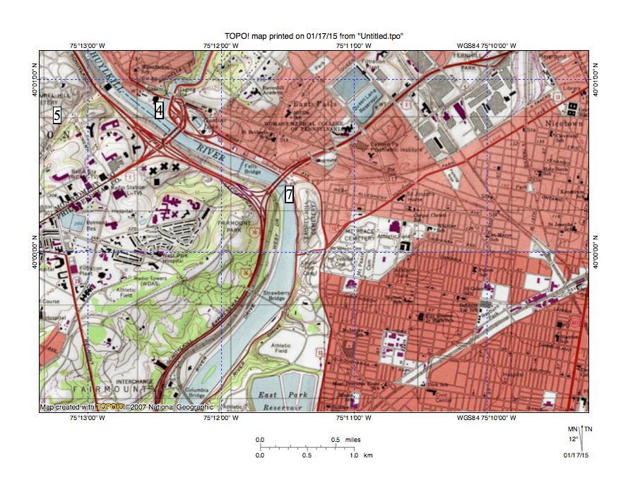
Figure 2: Location 4 shows where Wissahickon Creek enters the southeast oriented Schuylkill River valley. Location 7 shows where the Schuylkill River turns to flow in a southwest direction. United States Geological Survey map digitally presented using National Geographic TOPO software.
To better understand the picture puzzle pieces we need to look more closely at tributaries draining into both the Schuylkill Gorge and the Wissahickon Gorge. Almost all tributaries to the south-southeast oriented Wissahickon Gorge segment and the southeast oriented Schuylkill Gorge from the east and northeast are oriented in southwest directions while most Schuylkill Gorge tributaries from the southwest are oriented in northeast directions and join the Schuylkill River as barbed tributaries. Many, but not all tributaries entering the south-southeast oriented Wissahickon Gorge segment from the west are oriented in northeast directions and join Wissahickon Creek as barbed tributaries. This very pronounced southwest and northeast alignment of Wissahickon Gorge and Schuylkill Gorge tributaries strongly suggests the two gorges were eroded headward across a southwest oriented complex of anastomosing channels, such as might be formed during massive and probably prolonged floods.

Fig 3: Note southwest oriented tributaries to the south-southeast oriented Wissahickon Gorge (extending across center of map) and to the southeast oriented Schuylkill River Gorge (in map southwest corner). United States Geological Survey map digitally presented using National Geographic TOPO software.
Starting with the interpretation that the two gorges eroded headward across the same anastomosing channel complex the puzzle pieces can be assembled into a logical consistent picture. When the regional erosion began all regional elevations, including the through valley region north of the present-day Schuylkill and Wissahickon Gorges, was at least as high or higher than the highest elevations surrounding the Schuylkill and Wissahickon Gorges today. As massive southwest oriented floods moved across that initial surface, which has been completely removed, a deep valley began to erode headward along the present day Schuylkill River route to capture the southwest oriented flood flow channels. For most of its distance that deep valley eroded headward in a northwest direction across the southwest oriented flood flow channels, although for short segments the valley eroded headward along southwest oriented flood flow channels.
As the southeast oriented Schuylkill River valley segments eroded headward it captured flood flow from the southwest oriented complex of anastomosing flood flow channels and as each channel was captured the southwest oriented flow moved into the newly eroded and deeper Schuylkill River valley and began to erode southwest oriented valleys headward from the newly formed Schuylkill River valley wall. At the same time flood flow on the northeast ends of the beheaded flow channels reversed flow direction to flow back into the newly eroded and deeper Schuylkill River valley. Because the channels were anastomosing (converging and diverging) reversed flow in newly beheaded channels could capture southwest oriented flow from yet to be beheaded flood flow channels further to the northwest. Such captures enabled some of the beheaded and reversed flow channels to erode significant northeast oriented valleys.
The Wissahickon Gorge was originated as a captured southwest oriented flow channel eroded a valley headward from the newly eroded Schuylkill River valley wall, but subsequently eroded headward in a north-northwest direction to capture southwest oriented flow channels moving water to the newly eroded Schuylkill River valley. Again as the south-southeast oriented Wissahickon Creek valley eroded headward the captured southwest oriented flow channels eroded southwest oriented valleys headward into the newly eroded Wissahickon Creek valley wall while water on northeast ends of beheaded southwest oriented flow channels reversed flow direction (and captured flow from yet to be beheaded flow channels further to the north) so as to erode northeast oriented tributary valleys. And, as each southwest oriented flow channel was captured and beheaded that channel ceased to supply water to the newly eroded Schuylkill River valley.
Wissahickon Creek valley headward erosion did not behead flood flow channels being captured by the actively eroding Schuylkill River valley head and when the actively eroding Schuylkill River valley head eroded into easily eroded bedrock north of the erosion resistant bedrock band the Wissahickon Creek valley head was still actively eroding headward across the erosion resistant bedrock area and Schuylkill River tributary valleys were able to erode into easily eroded bedrock to capture southwest oriented flow moving north of the actively eroding Wissahickon Creek valley head. Southwest oriented flow moving to the newly eroded southwest and south oriented Spring Mill Creek valley carved what is today the Marble Hall Through Valley and southwest oriented flow moving to the newly eroded southwest and south oriented Plymouth Creek valley created what is today the Whitemarsh Through Valley. Wissahickon Creek valley headward erosion eventually captured all southwest oriented flow moving to the Spring Mill and Plymouth Creek valleys and created the landscape we see today.

Leave a comment