
The Whitemarsh Through Valley between Plymouth Creek and Wissahickon Creeks is one of several low elevation through valleys linking the Wissahickon Creek valley upstream from Wissahickon Gorge with the Schuylkill River and is a west to east oriented valley underlain by easily eroded bedrock and bounded on the south by an erosion resistant upland and on the north by ridges of erosion material. Wissahickon Creek flows in a south direction at the through valley east end and then enters its seven mile long Wissahickon Gorge carved into the erosion resistant upland before reaching the southeast oriented Schuylkill River. At the through valley west end Plymouth Creek flows in a southwest direction to reach the southeast oriented Schuylkill River just upstream from where the Schuylkill River enters its own gorge carved into the erosion resistant upland. A Norfolk Southern freight rail line makes use of the through valley to cross the Plymouth Creek-Wissahickon Creek drainage divide at an elevation of slightly more than 200 feet. The Marble Hall Through Valley located south of the Whitemarsh Through Valley has a slightly higher floor elevation and links the south oriented Wissahickon Creek valley with the southwest and south oriented Spring Mill Creek valley (which is located east and south of Plymouth Creek). The erosion resistant upland elevation on either side of the Wissahickon Creek Gorge, which is located downstream from the through valleys, exceeds 400 feet.
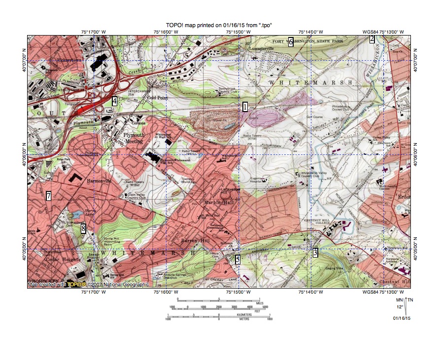
Figure 1: The Whitemarsh Through Valley (location 1) links south oriented Wissahickon Creek (locations 2 and 3) with southwest and south oriented Plymouth Creek (location 4). Location 3 shows where Wissahickon Creek enters the 7-mile long Wissahickon Gorge carved in a 400-foot high mass of erosion resistant material. Location 5 shows the Andorra Through Valley linking an east oriented Wissahickon Creek tributary with a west oriented Schuylkill River tributary. Location 6 is Militia Hill an erosion resistant ridge along the Whitemarsh Through Valley north margin. Locations 7 and 8 show a failed gorge that was beheaded by Plymouth Creek valley headward erosion. United States Geological Survey map digitally presented using National Geographic TOPO software.
The Whitemarsh Through Valley and Marble Hall Through Valley pose an intriguing question. Why and how did Wissahickon Creek erode a seven-mile gorge across a 400-foot high ridge of erosion resistant bedrock to reach the Schuylkill River when the Whitemarsh and Marble Hall Through Valleys provided much lower routes to reach the same Schuylkill River? Or, if the Wissahickon Gorge was eroded prior to erosion of the Whitemarsh and Marble Hall Through Valleys, then why and how were the Whitemarsh and Marble Hall Through Valleys eroded? The most logical answer to the questions is the Whitemarsh and Marble Hall Through Valleys were eroded at the same time that the Wissahickon Gorge was eroded. Otherwise, if one valley had been eroded before the other valleys all water would have flowed through the first valley and erosion of the other valleys would not have occurred. Then the question becomes, under what circumstances would it be possible to erode the Whitemarsh Through Valley, the Marble Hall Through Valley and the Wissahickon Gorge at the same time?
The Whitemarsh and Marble Hall Through Valleys did not exist at the time regional erosion began and water was flowing on a surface at least as high as the highest points surrounding the Wissahickon Gorge (more than 420 feet in Chestnut Hill on the gorge east side and near the Roxborough Filtration Plant on the gorge west side). Massive and prolonged floods, much larger than any recorded modern-day floods, must have moved across the region in a southwest direction to reach what at that time was an actively eroding southeast oriented Schuylkill River valley, which was eroding its gorge across the 400-foot high erosion resistant ridge. The Wissahickon Gorge eroded headward into the erosion resistant bedrock to capture southwest oriented flow moving across what is today an upland surface and eventually succeeded in eroding headward across the erosion resistant material and into the less erosional bedrock to the north, which underlies the Whitemarsh Valley.
At the same time the Schuylkill River valley was capturing more of the southwest oriented flood flow so it was able to erode its gorge across the erosion resistant material faster than Wissahickon Creek valley headward erosion across the same erosion resistant bedrock. Headward erosion of the Spring Mill Creek valley was able to first capture southwest oriented flow along the erosion resistant material north margin. Shortly thereafter the deep southeast oriented Schuylkill River valley head reached the north margin of the erosion resistant material (near present day Conshohocken) and the Plymouth Creek valley was able to erode headward across more easily eroded bedrock and was able to capture southwest oriented flow moving across the present day Whitemarsh Valley (although at first at an elevation of more than 420 feet) before headward erosion of the deep Wissahickon Gorge broke through the erosion resistant bedrock and reached the less erosion resistant material.
Southwest oriented flow moving to the newly eroded southwest and south oriented Plymouth Creek valley then lowered the Whitemarsh Valley at the same time the south oriented Wissahickon Creek valley eroded headward into the Whitemarsh Valley region. For a time the Marble Hall Through Valley to Spring Mill Creek, the Whitemarsh Through Valley Valley to Plymouth Creek and the Wissahickon Gorge competed with each other to capture the southwest oriented flow. However, the Wissahickon Gorge once eroded provided a shorter route to the Schuylkill River and as a result was eventually able to capture all southwest oriented flow moving along the Marble Hall and Whitemarsh Through Valley routes and then to capture large volumes of additional southwest oriented flow as it eroded still further headward (to eventually reach the present day Lansdale area). Large volumes of southwest oriented flow flow captured further to north continued to erode the Wissahickon Gorge floor and to create the south oriented Wissahickon Creek valley now seen crossing the Whitemarsh Valley.

Figure 2: Sandy Run drainage basin east of the Whitemarsh Through Valley. Sandy is a west oriented Wissahickon Creek tributary flowing from the map east edge to locations 2, 1, and 4. Location 3 shows a southwest oriented Sandy Run tributary. Locations 5 and 6 are on the erosion resistant ridge bounding the north side of this eastern extension of the Whitemarsh Through Valley. Location 7 is on the erosion resistant ridge forming the southeast margin of the valley eastern extension. United States Geological Survey map digitally presented using National Geographic TOPO software.

Leave a comment