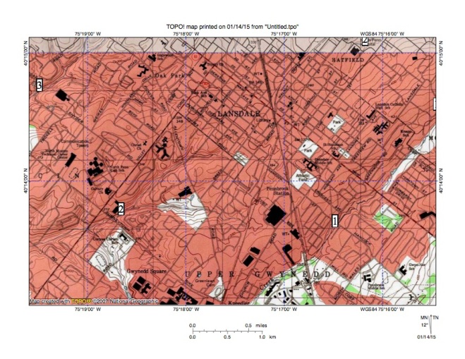
Wissahickon Creek originates near Lansdale at an elevation of approximately 400 feet and its headwaters flow in a southwest direction for a distance of approximately 4 miles before reaching an elevation of about 300 feet where the stream turns to flow in a southeast direction through its first water gap. Wissahickon Creek headwaters are bounded both to the north and south by northeast oriented headwaters of Neshaminy Creek tributaries. Northeast oriented headwaters of a West Branch Neshaminy Creek tributary are to the north while northeast oriented headwaters of northeast and east oriented Little Neshaminy Creek are to the south. And south of the Little Neshaminy Creek headwaters are northeast oriented headwaters of a Little Neshaminy Creek tributary (Little Neshaminy Creek is a Neshaminy Creek tributary). Wissahickon Creek eventually reaches the southeast oriented Schuylkill River while Neshaminy Creek eventually reaches the southwest oriented Delaware River meaning the Neshaminy-Wissahickon Creek drainage divide is also the Delaware River-Schuylkill River drainage divide and contains important information related to Delaware and Schuylkill River drainage basin origins.

Figure 1: Wissahickon Creek headwaters area. Wissahickon Creek begins at or near location 1 and flows in a southwest direction to the map southwest corner. Location 2 shows a northeast oriented West Branch Neshmany Creek tributary. Location 3 shows northeast oriented Little Neshaminy Creek headwaters and location 4 shows northeast oriented headwaters of a Little Neshaminy Creek tributary. Little Neshaminy Creek flows to Neshaminy Creek, which flows to the Delaware River. Wissahickon Creek flows to the Schuylkill River. United States Geological Survey map digitally presented using National Geographic TOPO software.
The northeast orientations of the adjacent Neshaminy Creek tributary headwaters and the southwest orientation of the Wissahickon Creek headwaters is an example of aligned drainage, which is commonly seen in the Philadelphia region. In fact, just west of the Wissahickon Creek headwaters are Towamencin Creek headwaters, which also include several southwest oriented segments. Towamencin Creek flows in a west and southwest direction to join south and southwest oriented Skippack Creek, which then flows to south oriented Perkiomen Creek with the water eventually reaching the southeast oriented Schuylkill River.

Figure 2: Towamencin Creek headwaters are located just west of the Wissahickon Creek headwaters. Wissahickon Creek flows in a southwest direction from the map northeast corner to location 1 and then to the map south edge. Locations 2 and 3 identify southwest oriented Towamencin Creek headwaters. Note, not all Towamencin Creek headwaters have the same southwest orientation as the Wissahickon Creek headwaters and some Towamencin Creek headwaters have distinctly different orientations. These different orientations are difficult to explain if geologic controls are the primary factor controlling the regional aligned drainage, but can be explained by headward erosion of deep valleys across a flood formed complex of southwest oriented anastomosing channels. United States Geological Survey map digitally presented using National Geographic TOPO software.
To understand the aligned drainage in the Wissahickon Creek headwaters region we need to ask why do Wissahickon Creek and Towamencin Creek headwaters flow in southwest directions while adjacent Neshaminy Creek tributaries originating on either side of the Wissahickon Creek headwaters flow in a northeast direction? It is possible, and even probable that the northeast and southwest stream orientations are to some extent geologically controlled. If so, the geologic factors controlling the aligned drainage are weak because many stream segments in the Wissahickon Creek, Neshaminy Creek, and Towamencin Creek drainage basins are oriented in other directions. Plus there is the complication that the northeast oriented Neshaminy Creek tributary headwaters are on both sides of the southwest oriented Wissahickon Creek headwaters.
The southwest oriented Wissahickon and Towamencin Creek headwaters and the northeast oriented Neshaminy Creek tributary headwaters can be interpreted as being relics of what was once a southwest oriented complex of anastomosing channels that once crossed the entire region. Northeast oriented Neshaminy Creek tributary segments probably were formed by reversals of flow on the northeast ends of beheaded southwest oriented channels captured by headward erosion of the deeper Neshaminy Creek valley (further to the east). Evidence seen in the Wissahickon Creek headwaters area if looked at in isolation can be interpreted in other ways, but definitely supports similar evidence seen throughout the Philadelphia region suggesting that all Philadelphia area valleys eroded headward across a southwest oriented anastomosing channel complex, which might be formed if massive and prolonged floods crossed the region.

Leave a comment