
Route 309 and an abandoned rail line cross Edge Hill Ridge at the Seminary Wind Gap, with Westminster Theological Seminary being located on the wind gap northeast rim. The Seminary Wind Gap is one of three wind gaps cut into the Wissahickon Creek-Tacony Creek drainage divide along the northeast oriented Edge Hill Ridge with the other two wind gaps being the Edge Hill Wind Gap and the Ardsley Wind Gap, both to the northeast. The Laverock Wind Gap, which is located between the Edge Hill Ridge and Chestnut Hill, is one-half southeast from the Seminary Wind Gap. The Seminary Wind Gap floor elevation was probably about 350 feet before being altered by railroad and highway construction. Edge Hill Ridge crest elevations vary but exceed 400 feet at numerous points. The region north of the Seminary Wind Gap is drained today by west oriented Wissahickon Creek tributaries with Wissahickon Creek being a south oriented Schuylkill River tributary. South of the Seminary Wind Gap water today drains to the Tacony Creek (also known as Tookany Creek) headwaters valley, which drains in an east direction through Glenside to reach the Jenkintown Elbow Of Capture. At the elbow of capture Tacony Creek turns to flow in south-southeast direction and eventually reaches the southwest oriented Delaware River. The Seminary Wind Gap is located on the Schuylkill River-Delaware River drainage divide. While not as spectacular as wind gaps elsewhere in Pennsylvania the Seminary Wind Gap provides important scientific information related to the Delaware River and Schuylkill River drainage basin origins.
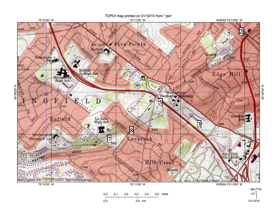
Figure 1.The Seminary Wind Gap is found at location 5 near the map center. Tacony (Tookany) Creek begins near location 3 and flows in an east direction to the Jenkintown Elbow of Capture, where it turns to flow in a south-southeast direction and eventually reach the Delaware River. Beaver College is now Arcadia University. Whitemarsh Research Lab, La Salle High School, Westminster Theological Seminary, and Edge Hill are located on the northeast oriented Edge Hill Ridge. All regions north and west of the Edge Hill Ridge now drain to south oriented Wissahickon Creek (located west of the map). Location 7 shows headwaters of a west oriented Wissahickon Creek tributary and location 8 is the Laverock Wind Gap, which is a notch between the Edge Hill Ridge and the Hill Crest upland (Chestnut Hill) to the south. United States Geological Survey map digitally presented using National Geographic TOPO software.
The Seminary Wind Gap is located near where the east oriented Tacony Creek headwaters valley begins and as mentioned is also near the Laverock Wind Gap where a west oriented Wissahickon Creek tributary valley begins. The Laverock Wind Gap was eroded by west oriented flow to the actively eroding Wissahickon Creek valley just prior to headward erosion of the much deeper south oriented Tacony Creek valley, which beheaded and reversed the west oriented flow channel to create the east oriented Tacony Creek headwaters valley. The Seminary Wind Gap was probably eroded as reversed flow on the newly reversed Tacony Creek headwaters alignment captured flow moving on a high-level surface north of the present day Edge Hill Ridge. This captured flow then moved across the present day Edge Hill Ridge location and cut the Seminary Wind Gap, but the erosion resistant bedrock limited the ability of the Tacony Creek valley head to erode headward across the present day Edge Hill Ridge. It is possible that for a period of time some water moving through the Seminary Wind Gap moved across the Laverock Wind Gap to the west oriented Wissahickon Creek tributary valley. If so Tacony Creek valley headward erosion subsequently captured all flow to the Laverock Wind Gap and all final flow through the Seminary Wind Gap was to the east oriented Tacony Creek headwaters valley. South oriented flow through the Seminary Wind Gap ended as the deep Wissahickon Creek valley eroded headward into the present day Whitemarsh Valley region and southwest oriented flow moving to the newly eroded and deep Wissahickon Creek valley lowered elevations north of the Edge Hill Ridge, which left the Edge Hill Ridge as an erosional residual standing above the surrounding landscape.

Leave a comment