
The Laverock Wind Gap with a floor elevation slightly greater than 350 feet is located just south of the northeast trending Edge Hill Ridge and links the east oriented Tacony Creek headwaters valley with a west oriented Wissahickon Creek tributary valley (which drains to the Wissahickon Gorge north entrance). Wissahickon Creek drains to the southeast oriented Schuylkill River while Tacony Creek drains to the southwest oriented Delaware River. In other words the Laverock Wind Gap is located on the Schuylkill River-Delaware River drainage divide and not only provides information related to the Wissahickon Creek and Tacony Creek drainage basin origins, but it also provides information related to the Schuylkill River and Delaware River drainage basin origins.
The Wissahickon Creek-Tacony Creek drainage divide extends in north direction from the Laverock Wind Gap to the adjacent Edge Hill Ridge crest and then extends in a northeast direction along the ridge crest, which is notched by three additional wind gaps, the Seminary Wind Gap, the Edge Hill Wind Gap, and the Ardsley Wind Gap. Elevations along the Edge Hill Ridge crest generally exceed 400 feet except at the wind gap locations. The Seminary and Edge Hill Wind Gap floor elevations prior to being altered by railroad and highway construction were probably about 350 feet or approximately the same as the Laverock Wind Gap floor elevation. The Ardsley Wind Gap floor elevation is approximately 25 feet deeper than the other three wind gaps. The similarity of the Laverock Wind Gap floor elevation to the floor elevations of the Seminary and Edge Hill Wind Gaps suggests those three wind gaps were probably eroded at approximately the same time under similar conditions, The Ardsley Wind Gap greater depth suggests water continued to erode the channel crossing the Edge Hill Ridge at Ardsley for a period of time after flow had ceased to move through the Edge Hill, Seminary, and Laverock Wind Gaps.
South of the Laverock Wind Gap the Wissahickon Creek-Tacony Creek drainage divide is oriented in a south direction across the Chestnut Hill upland surface where elevations exceed 400 feet. The Laverock Wind Gap is a water-eroded feature and the valley was initiated as a west oriented channel draining along the Edge Hill Ridge southeast flank to what at that time was the north (or upstream) entrance to the south oriented Wissahickon Gorge and then to what at that time was an actively eroding southeast oriented Schuylkill River valley. At that time elevations in the present day Sandy Run drainage basin (a Wissahickon tributary drainage basin) to the north of the Edge Hill Ridge were still as high or higher than the Edge Hill Ridge crest elevations today and southwest oriented flow in Sandy Run drainage basin area could move in a south direction to reach the newly eroded and deeper channel located along the Edge Hill Ridge southeast flank. The southwest and west oriented flow channel was beheaded by headward erosion of the much deeper Tacony Creek valley in the Jenkintown Elbow of Capture location and flow in the channel (east of the Laverock Wind Gap) was reversed so as to move towards the newly eroded and much deeper south-oriented Tacony Creek valley at the Jenkintown Elbow of Capture location. For a period of time following the reversal of flow in the east oriented Tacony Creek headwaters valley water moving south from the present day Sandy Run drainage basin area helped erode the east oriented Tacony Creek headwaters valley (and may have also further eroded the west oriented Wissahickon Creek tributary valley). South oriented flow ended as the deep Wissahickon Creek valley eroded headward into the Whitemarsh Valley region and southwest oriented flow moving to the newly eroded and deep Wissahickon Creek valley lowered elevations north of the Edge Hill Ridge, which left the Edge Hill Ridge as an erosional residual standing above the surrounding landscape.
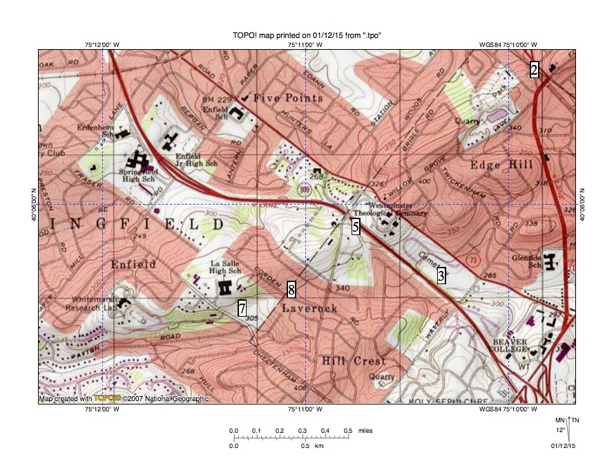
Figure 1. The Laverock Wind Gapis found at location 8. Headwaters of a west oriented Wissahickon Creek tributary are at location 7 and Tacony Creek headwaters are at location 3. La Salle High School (near location 7) is located on the Edge Hill Ridge, which continues in a northeast direction to the map northeast corner. Location 5 is the Seminary Wind Gap and location 2 is the Edge Hill Wind Gap. United States Geological Survey map digitally presented using National Geographic TOPO software.

Leave a comment