
Tacony Creek flows in an east direction from its headwaters area through Glenside to the SEPTA Lansdale Regional Rail line, near the SPS technologies plant, and then turns to flow in a south-southeast direction between Jenkintown and Wyncote. The turn from flowing in an east direction to flowing in a south-southeast direction is here referred to as the Jenkintown Elbow of Capture. To understand how the elbow of capture was created it is necessary to recognize some through valleys that also converge at the elbow of capture location. The elbow of capture location is also an important rail junction location with the SEPTA Lansdale Regional Rail line, which has followed the south-southeast oriented Tacony Creek valley northward from Elkins Park to the elbow of capture location. The Lansdale line proceeds from the elbow of capture location in a northwest oriented valley to the Edge Hill Wind Gap and then continues to points in the Wissahickon Creek drainage basin. Diverging from the Lansdale line at the elbow of capture the SEPTA West Trenton line proceeds in an east-northeast direction on the floor of a broad 130-foot deep or deeper through valley, which links the Tacony Creek valley with the south oriented Pennypack Creek valley (near Bethayres). Joining the valleys used by these converging rail lines at the Jenkintown elbow of capture is the east oriented Tacony Creek headwaters valley.
The broad east-northeast or west-southwest oriented through valley used by the SEPTA West Trenton line between Jenkintown and Bethayres provides evidence that large volumes of water once flowed from the Pennypack Creek drainage basin (in the Bethayres region) to the south-southeast oriented Tacony Creek valley at Jenkintown. West-southwest oriented flow carved this broad valley at least 130 feet deep and was eventually beheaded by headward erosion of the deeper south oriented Pennypack Creek valley. Flow on the east-northeast end of this west-southwest oriented flow channel reversed to flow in an east-northeast direction and to create what is today the east-northeast oriented Meadow Brook tributary to south oriented Pennypack Creek. Baederwood Creek today flows in a south direction to enter the through valley southwest end and then flows in a southwest direction to join Tacony Creek at the elbow of capture location. The deep and broad through valley extending from Jenkintown to Bethayres is referred to here as the Meadow Brook Through Valley. Large volumes of west-southwest oriented water moving on the Meadow Brook Through Valley alignment (although at an elevation at least 130 higher than the through valley floor elevation today) were captured by headward erosion of the south-southeast oriented Tacony Creek valley head into the Jenkintown area. Prior to the capture much of the water was flowing from the Jenkintown Elbow of Capture location along the present day Tacony Creek headwaters alignment. Headward erosion of the deep Tacony Creek valley beheaded and reversed that east oriented flow to create the present day east oriented Tacony Creek headwaters segment.
The Meadow Brook Through Valley depth also suggests that prior to headward erosion of the deep south oriented Tacony Creek valley water was moving in a west-southwest and west direction along the present day east oriented Tacony Creek headwaters alignment, although at an elevation at least 130 feet higher than the present day Tacony Creek elevation at the Jenkintown elbow of capture. In other words it was this west oriented flow channel that for a time moved water across the Laverock Wind Gap valley to reach the upstream or north Wissahickon Gorge entrance that was captured by headward erosion of the deep south oriented Tacony Creek valley. Capture of the west-southwest oriented flow beheaded the west oriented channel leading to the Laverock Wind Gap and Wissahickon Gorge north entrance and caused the reversal of flow that resulted in the erosion of the east oriented Tacony Creek headwaters valley.
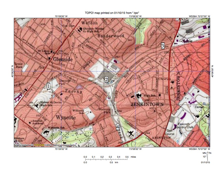
Figure 1: Jenkintown elbow of capture. Location 1 shows Tacony Creek flowing in an east direction through Glenside to its Jenkintown Elbow of Capture (location 2) where it is joined by the southwest oriented Meadow Brook Through Valley (location 3) and turns to flow in a south-southeast direction to and beyond location 4. United States Geological Survey map digitally presented using National Geographic TOPO software.

Leave a comment